
Like us on Facebook
PLACE NAMES


|
|
Widnes
|
| |
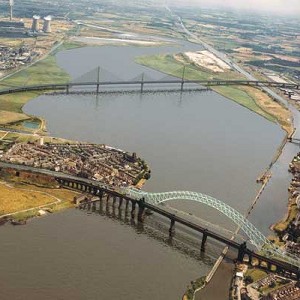
Widnes is situated on the north bank of the River Mersey. The whole town is low-lying with some slightly higher areas in Farnworth and Appleton. To the south of the town a spur projecting into the river forms the West Bank area of Widnes; together with a spur projecting northwards from Runcorn these form Runcorn Gap, a narrowing of the River Mersey. Runcorn Gap is crossed by Runcorn Railway Bridge, carrying the Liverpool branch of the West Coast Main Line, and the Silver Jubilee Bridge, carrying the A533 road which then curves in a westerly direction towards Liverpool becoming the A562. The density of housing is generally high but there are some open green areas, including Victoria Park in Appleton and two golf courses which are geographically near the centre of the urban development. Most of the chemical and other factories are close to the north bank of the River Mersey. A second crossing of the Mersey is planned, to be known as the Mersey Gateway.
Drainage of the Widnes area is into the Mersey via Dutton, Steward's and Bower's Brooks. The bedrock of the area is rock from the Sherwood sandstone group. There are a few outcrops of sandstone but elsewhere the bedrock is covered by drift. Most of this consists of till except near the bank of the Mersey where it is recent alluvium. Large areas are also covered by industrial waste.
When borings were made in the 1870s prior to the building of chemical works a deep gorge measuring around 100 feet (30 m) was found in the bedrock which was filled with glacial deposits. From this it was concluded that before the Ice Age the Mersey had flowed in a more northerly course, and when it was blocked by glacial deposits it had made a new channel through Runcorn Gap.
Being close to the west coast and the Irish Sea, the climate is generally temperate with few extremes of temperature or weather. The mean average temperature in the years 1971 to 2000 was 9.4 to 9.7 °C, which was slightly above the average for the United Kingdom as was the average amount of annual sunshine at 1391 to 1470 hours. The average annual rainfall was 741 to 870 mm, which was slightly below the average for the UK. The average number of days in the year when snow is on the ground is 0 to 6, which is low for the United Kingdom. The average number of days of air frost is 2 to 39, which is also low.
Widnes had a population of 58,300 in 2010. Directly to the south across the Mersey is the town of Runcorn. Upstream and 8 miles (13 km) to the east is the town of Warrington, and downstream to the west is Speke, part of the city of Liverpool.
Before the Industrial Revolution Widnes was made up of small settlements on marsh and moorland. In 1847, the first chemical factory was established and the town rapidly became a major centre of the chemical industry. The demand for labour was met by large-scale immigration from Ireland, Poland, Lithuania and Wales. The town continues to be a major manufacturer of chemicals .
Widnes station is on the Liverpool to Manchester line. The main roads through the town are the A557 in a north-south direction and the A562 east-west. The disused Sankey Canal terminates in an area known as Spike Island.
The most usual explanation for the origin of the name Widnes is that it comes from the Danish words vid, meaning wide, and noese, meaning nose and that it refers to the promontory projecting into the River Mersey. However the Widnes promontory is not particularly wide and another possible explanation is the first part derives from the Danish ved, meaning a wood and possibly referring to a tree-covered promontory. Earlier spellings of the name have been Vidnes, Wydnes and Wydness.
|
 Feel free to Email me any additions or corrections Feel free to Email me any additions or corrections
LINKS AVAILABLE TO YOUR SITE
| |
