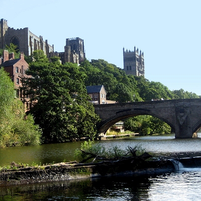
Durham is situated 13 miles (21 km) to the south west of Sunderland. The River Wear flows north through the city, making an incised meander which encloses the centre on three sides to form Durham's peninsula.
At the base of the peninsula is the Market Place, which still hosts regular markets; a permanent indoor market, Durham Indoor Market, is also situated just off the Market Place. The Market Place and surrounding streets are one of the main commercial and shopping areas of the city. From the Market Place, the Bailey leads south past Palace Green; The Bailey is almost entirely owned and occupied by the university and the cathedral.
Durham is a hilly city, claiming to be built upon the symbolic seven hills. Upon the most central and prominent position high above the Wear, the cathedral dominates the skyline. The steep riverbanks are densely wooded, adding to the picturesque beauty of the city. West of the city centre, another river, the River Browney, drains south to join the Wear to the south of the city.
Durham had a total population of 87,656 in 2001, covering 186.68 square kilometres in 2007. In 2001, the unparished area of Durham had a population of 29,091, whilst the built-up area of Durham had a population of 42,939.
There are three old roads out of the Market Place: Saddler Street heads south-east, towards Elvet Bridge, the Bailey and Prebends Bridge. Elvet Bridge leads to the Elvet area of the city, Durham Prison and the south; Prebends Bridge is smaller and provides access from the Bailey to south Durham. Heading west, Silver Street leads out of the Market Place towards Framwellgate Bridge and North Road, the other main shopping area of the city. From here, the city spreads out into the Framwelgate, Crossgate, Neville's Cross and viaduct districts, the other main shopping area of the city. Beyond the viaduct lie the outlying districts of Framwellgate Moor and Neville's Cross. Heading north from the Market Place leads to Claypath. The road curves back round to the east and beyond it lie Gilesgate, Gilesgate Moor and Dragonville.
Many of the inner city areas are now inhabited by students living in shared houses.
|