Like us on Facebook
PLACE NAMES


|
|
Rainham
|

|
|
|
Rainham is recorded in the Domesday Book of 1086 as Raineham and is thought to mean 'homestead or village of a man called Regna', formed from an Old English name and 'ham', meaning settlement. It is also possible that it follows Rainham, Kent which is thought to derive 'home of the Roegingas'. This is also of uncertain meaning, but could refer to 'the ruling people'.
Rainham is mostly situated on gravel, rising to between 60 feet (18 m) and 100 feet (30 m). The marshlands along the southern boundary of the River Thames are about 5 feet (1.5 m) above sea level and a tidal section of the River Ingrebourne forms the western boundary. It is located in part of London that is susceptible to flooding. The historic core of Rainham, including the town centre, forms a conservation area. The land to the south has been affected by gravel extraction and 200 acres of Rainham Marshes has been filled with 9 million tons of dredged soil by the Port of London Authority. Rainham is a post town in the RM postcode area; it covers a wide area of southern Havering and additionally includes Coldharbour, South Hornchurch and Wennington.
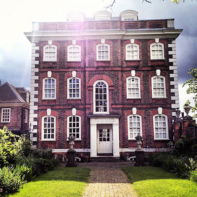
The earliest development was around the Church of St Helen and St Giles, and this is the only medieval building to survive. New prosperity from increased trade in the early 18th century led to several new buildings, including Rainham Hall. Roads were laid out in 1880 and the new developments consisted of semi-detached and terraced houses. At the same time a community developed around a pub on the river and operated as a resort for day-trippers. As the Thames industrialised it declined in popularity and was gone by 1945. Rainham developed into a suburb of London after World War I. As the estates were broken up for housing some land was purchased by smallholders from Bow and West Ham. In the 1940s they successfully campaigned against having it returned to agricultural use and it was excluded from the Metropolitan Green Belt. The roadways and sewerage systems did not keep up with the rate of growth and a residents' group fought for improvements in infrastructure throughout the 1960s.
|
 Feel free to Email me any additions or corrections Feel free to Email me any additions or corrections
LINKS AVAILABLE TO YOUR SITE
| |


