Like us on Facebook
PLACE NAMES


|
|
Formby
|

|
|
|
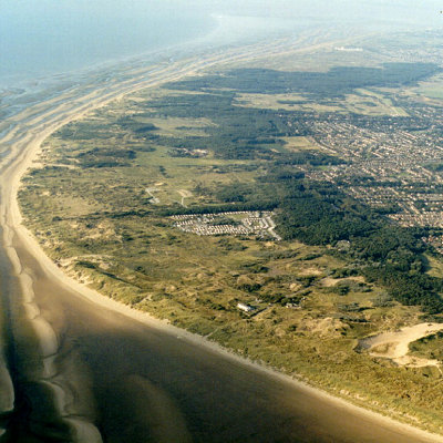
Formby is a coastal town roughly 7 sq miles (17km²) and part of Sefton in the north west of Merseyside. The town is built upon the west of a large flat area of land called the West Lancashire Coastal Plain. The town is 1.5 feet (0.5 metres) below sea level at its lowest point. Formby's highest point is within the sand dunes that separate the Irish Sea from Formby, sand dunes are ever changing in shape and formation so there is no fixed point. The River Alt runs in to the Irish Sea just south of Formby at Hightown.
The town is rurally landlocked; the land between Formby and the areas of Southport, Ormskirk and Liverpool is green belt land and is used for arable agricultural purposes. The areas around the urban fringe are drained by irrigation ditches are open areas get boggy in the winter months. Earth in urban areas is well drained, very loose and sandy.
The section of land between Formby and the coast is varied in vegetation, wildlife and terrain. This area includes pine forests: natural and man-made, sand dunes, marram grass, deciduous woodland, seasonal ponds and lakes. Large areas of this land are protected by the National Trust.
Formby is in a temperate climate zone, with mild winters and warm summers. Formby's biggest threat is global warming as the town is built on a flood plain, being situated next to the coast and being below sea level.
Formby Hall is a Grade II listed building dating back to 1223. It has traditionally been the home of the Lords of the Manor. Much of the land around it is now a golf course.
Formby beach is the location of the first lifeboat station in the UK. Established perhaps as early as 1776 by William Hutchinson, Dock Master for the Liverpool Common Council. It was the first lifeboat station in the United Kingdom, and possibly the world. The foundations of the last of the lifeboat station buildings remain on the beach. The last launch took place in 1916. Remarkably a film survives of this event.
Formby is home to RAF Woodvale, a small RAF station on the outskirts of the town. The airport, opened in 1941, is a former WW2 fighter base with three active runways, the main runway being a mile in length. It is used by RAF for light aircraft and fighter training, as well as a few civilian aircraft. The station is also home to Merseyside Police's helicopter, known as 'Mike One'. The RAF Station was also home to the last ever operational service of the British legend, the Spitfire (in case of an invasion from Ireland?). In 1957 the last Spitfire was to fly with military markings in British took off from Woodvale on an operational mission. Woodvale is also home to the Woodvale Rally, one of the biggest shows on an active MOD station in the North West.
Holy Trinity Church is believed to be the only church in the country which holds a special service in which seasonal greenery collected by the menfolk of the parish and then twined into wreaths by the ladies is lifted into place as part of a service of worship in the run-up to Christmas.
ormby - The common place-name ending -by is from the Scandinavian abyr meaning "homestead", "settlement" or "village". It is a derivation of the verb "to be" - hence, the place where you "be" (or are). The village of Formby was originally spelt Fornebei and means "village belonging to Forni". At that time Fornibiyum was a well-known Norse family name. He could have been the leader of the invading expedition which took possession of this coast. Until its closure in 1998, Oslo Airport in Norway was situated in a town called Fornebu. It was from Ireland in about 960 AD that these Norsemen or Vikings first came to the west coast of Lancashire, first trading or raiding and then settling. Tradition says that the Viking invaders failed to defeat the native Anglo-Saxons on the coast of Formby, so they sailed inland, up the River Alt, and attacked from the rear. It is more probable that the Viking invaders simply found that the area was thinly populated and took control without any blood being shed. It is thought that the Romans used Formby as a major pass through for their troops during the time of their settlement.
|
 Feel free to Email me any additions or corrections Feel free to Email me any additions or corrections
LINKS AVAILABLE TO YOUR SITE
| |


