
Like us on Facebook
PLACE NAMES


|
| Mansfield
|  |
|
|
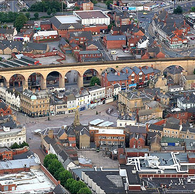
Settlement in the Mansfield area is known to date back to Roman times, with a villa discovered in 1787 by a Major Rooke between Mansfield Woodhouse and Pleasley and a cache of denarii coins found near King's Mill in 1849. After the end of Roman occupation, the early English royalty are said to have stayed there, with the Mercian Kings having used it as a base for hunting in the nearby Sherwood Forest.
The Domesday Book compiled in 1086 has the settlement recorded as Mammesfeld whereas in later market-petition documents of 1227 the spelling had changed to Maunnesfeld. By the time of King Richard II signing a Warrant in November 1377 granting the right for the tenants to hold a fair every year for four days, the spelling had changed again to Mannesfeld.
There are remains of the 12th century King John's Palace, in Clipstone between Mansfield and Edwinstowe. The area was originally a retreat for royal families and dignitaries in the 14th and 15th centuries due to its location within Sherwood Forest famed for its fresh air and exclusiveness. Access to the town was via a small horse-drawn carriageway from the city of Nottingham that was en route to Sheffield.
On West Gate within the town centre, a commemorative wall plaque marks the point that was thought to be the centre of Sherwood Forest 2013. A tree has been planted nearby.
Access to the town between the 16th and 17th centuries was via several inns and stable yards. The Harte, the Swan (which has a dating stone with 1490 was found during alterations), the Talbot, the White Bear, the Ram (timber dating to pre 1500) and the White Lion were known to date from medieval times. Several timber-framed cruck buildings were demolished in 1929 and another in 1973 which was documented by a local historical society during its demolition and was dated at circa 1400, or earlier. Other Tudor houses on Stockwell Gate, Bridge Street and Lime Tree place were also demolished to make way for new developments before they could be viewed for being listed properties. The majority of buildings remaining are from the 17th century onwards.
Mansfield has many parks and green spaces. Titchfield Park, located on the same site as the Water Meadows swimming complex, offers large grassy areas on both sides of the river Maun, crossed by two foot bridges. The park boasts a bowls green, hard tennis courts, basketball court, children's play area and many flowerbeds which are filled with blooms during the summer months.
Fisher Lane Park, located nearby stretching from the top of Littleworth through to Rock Hill, is a green space popular with dog walkers, kite flyers and skaters, since Mansfield District Council installed a concrete skate plaza, causing some controversy with locals.
However, the skate plaza has proven to be very popular with local youths, who access it daily. During the summer months, small fairs use Fisher Lane Park to set up some rides and stalls for local children.
Carr Bank Park is another park close to the town, which has a rocky 'grotto', bandstand and many flower beds, which are filled with blooms during the summer. The park has a new war memorial built of local sandstone dedicated to those who were killed in action since the end of the Second World War, to compliment the original setting unveiled after the First War in 1921.
|
 Feel free to Email me any additions or corrections Feel free to Email me any additions or corrections
LINKS AVAILABLE TO YOUR SITE
| |

