
Like us on Facebook
PLACE NAMES


|
|
Helmsley
|
|
View Larger Map |
|
In Domesday, it was Elmslac - Helm's clearing.
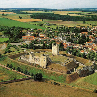
Helmsley is a market town and civil parish in the Ryedale district of North Yorkshire, England. Historically part of the North Riding of Yorkshire, the town is located at the point where the valleys of Bilsdale and Ryedale leave the moorland and join the flat Vale of Pickering.
It is situated on the River Rye and lies on the A170 road, 14 miles (23 km) east of Thirsk, 13 miles (21 km) west of Pickering and some 24 miles (39 km) due north of York. The southern boundary of the North York Moors National Park dissects Helmsley into two along the A170 road, with the western part of the town lying within the National Park.
The settlement grew up largely as a result of its position at a road junction and river crossing point. Helmsley is a compact town, retaining its medieval layout around its market place with more recent development to the north and south of its main thoroughfare, Bondgate. It is an historic town of considerable architectural character whose centre has been designated as a Conservation Area. The town is associated with the Earls of Feversham whose ancestral home Duncombe Park was built overlooking the castle. A statue of William Duncombe, 2nd Baron Feversham stands in the town's square. The town is a popular tourist centre and has won gold medals in the Large Village category of Yorkshire in Bloom for the last three years. The town square is a popular meeting place for motorcyclists as it is at the end of the B1257 road from Stokesley, which is a favourite with bikers.
The Cleveland Way National Trail starts at Helmsley, and follows a horseshoe loop around the North York Moors National Park for 110 miles (180 km) through to Filey. The remains of Helmsley Castle tower over the town. Other places of interest include the International Centre for Birds of Prey, Rievaulx Abbey and Helmsley Arts Centre.
|
 Feel free to Email me any additions or corrections Feel free to Email me any additions or corrections
LINKS AVAILABLE TO YOUR SITE
| |

