
Like us on Facebook
PLACE NAMES


|
|
Porto-Veccio
|
 |
|
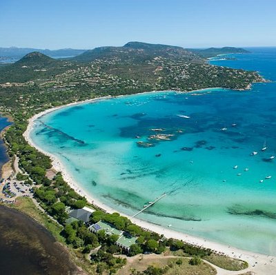
The canton of Porto-Vecchio has a population of about 12,900 living in four communes making up a total of 34,787 hectares (85,960 acres). It is divided in two by the commune of Zonza, which holds a section of the coast around the Gulf of Pinarellu. Porto-Vecchio has two communes to the north, Sari-Solenzara and Conca, and two to the south, Porto-Vecchio and Lecci.
The commune of Porto-Vecchio is 64 kilometers (40 mi) east of Sartène. The north shore of the gulf has many resorts, such as Benedettu, Marina di Fiori, and others of the commune of Lecci. The east coast, a shore with cliffs, is less habitable; beyond Chiappa Point (a naturist site) the coast goes southwest to the border of Bonifacio commune.
Off the southeast shore are the four îles Cerbicale (seldom shown on the map but visible from satellite photographs), protected by a nature reserve of 36 hectares (89 acres), which are part of the larger reserve of Bouches de Bonifacio ("Straits of Bonifacio"; see under Bonifacio). From north to south are: Forana; Maestro Maria, the smallest; Piana, the largest, which ascends to 36 meters (118 ft) and Pietrocaggiosa a little more distant.
Hills to the northwest are included in the national park; the village of Ospedale there probably takes its name and origin from a large ancient hospital of the Roman era. It never lost that function but continues as a health center employing about 150 people. Nearby is a reservoir, the Lac de l'Ospedale, created with a dam at the foot of punta di Corbu in the forest of Ospedale. These hills culminate at the 1,314 meters (4,311 ft) "peak of the dead cow" (punta di a Vacca Morta).
 Feel free to Email me any additions or corrections Feel free to Email me any additions or corrections
LINKS AVAILABLE TO YOUR SITE
| | |

