
Like us on Facebook
PLACE NAMES


|
|
Rochechouart
|
|
|
|
Rochechouart is situated at the confluence of the River Grêne and the River Vayres on the Plateau of Limousin, about 180 m (590 ft) above sea level.
It is about 9 km (5.6 mi) south of Saint-Junien, the second largest town in the department of Haute-Vienne, and 45 km (28.0 mi) west of Limoges, the largest town and capital of the department. To the west lie the communes of Pressignac and Chassenon in the department of Charente, to the north lie the communes of Saillat-sur-Vienne and Chaillac-sur-Vienne, to the east lies Saint-Auvent and to the south Vayres.
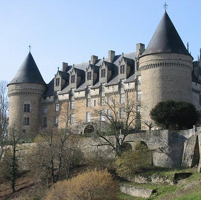
The walled town of Rochechouart is overlooked by the château and houses a museum, the "Espace Meteorite Paul Pellas" which commemorates the meteorite crater. The château was taken over by the community in 1832 and now houses the town hall as well as a modern art collection, the "Musée Départmental d'Art Contemporain".
Rochechouart is situated in the Rochechouart crater, an impact crater caused by a meteorite that crashed into the earth's surface about 214 million years ago, in the Rhaetian period, around the Triassic Jurassic boundary. Little is visible on the ground now because of erosion, but the event is witnessed by the impact effects on the surrounding rocks. This crater is one of five impact craters that occurred at around the same date, the others being in Quebec, Manitoba, North Dakota and Ukraine. Tectonic plates have moved since then, but it has been calculated that three of these craters are exactly aligned, and the other two lie on identical declination paths to two of the other three. It is hypothesized that they may have been part of a multiple impact event, caused perhaps by the breaking up of a comet. These impacts may have been the trigger for the Triassic–Jurassic extinction event in which 80% of the world's species were obliterated.
 Feel free to Email me any additions or corrections Feel free to Email me any additions or corrections
LINKS AVAILABLE TO YOUR SITE
| | |

