
Like us on Facebook
PLACE NAMES


|
|
Salles-la-Source
|
|
|
Salles-la-Source is a commune in the Aveyron department in southern France. The Rodez-Marcillac Airport is located in Salles-la-Source.
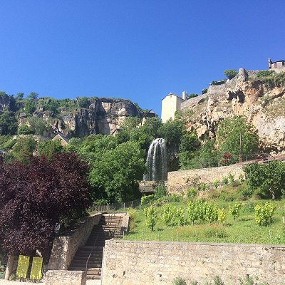
Built in the hollow of a natural limestone cirque from which springs a beautiful waterfall, the village of Salles-La-Source was the seat of an important co-lordship, Its succession of towers and bell towers testifies.
Discovery tour to do in autonomy to pick up at the Tourist Office of Marcillac.
On the upper level, in the heart of the circus, there is a pleasant square, with two fountains, and lined with walnut trees. A characteristic species of the region, the nuts were formerly the subject of a real trade and were in particular transformed into oil in the many mills of the village.
To the north of the square is the Château des Waves or minor castle, seat of authority count after the abandonment of the major castle. Among the oldest fortified houses co-lords, the minor castle has two beautiful 12th century round towers with battlements, defense works, as well as Renaissance mullioned windows.
Looking around the square, you will see houses with cornices, corbels and/or timber frames, characteristics of medieval times. You will see more
examples throughout.
In the rue de la source, the barn on the right bears witness to the importance of agriculture on the Causse Comtal plateau, a veritable breadbasket
wheat from Rouergue; the cereals produced were then processed in mills for home consumption.
You now pass the Créneau whose source is in the rock upstream. More than a natural watercourse, it is a developed canal that allowed to feed the many mills of the village. Note: the barrel octagonal of a 12th century cross (recently restored by a local craftsman).
By making a small detour by the staircase behind you, you will see a old mill with its millstone as well as the penstock that channels the water
to use hydropower since 1936.
Continuing the rue de la source, notice on your left another fortified house with round tower. A little lower on your right, you have the traces of the landslide of apart of the cliff occurred in 2005; above the water point notice how rock (tuff) is formed by limestone deposits on vegetation (ferns).
Now go up on your right to the interpretation table landscape. You are on what was once a Roman road then later the chemin du comte, the first access to the village before the construction in the 19th century of the departmental road along the Favi, a stream which joins the Créneau at the bottom of the village.
 Feel free to Email me any additions or corrections Feel free to Email me any additions or corrections
LINKS AVAILABLE TO YOUR SITE
| | |
