
Like us on Facebook
PLACE NAMES


|
|
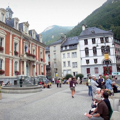
Cauterets
|
|
|
Cauterets is a spa town, a ski resort and a commune in the Hautes-Pyrénées department and the region of Occitanie in south-western France.
Cauterets is located 32 km (20 mi) southwest of Lourdes and borders the Pyrenees National Park. Surrounded by the high mountains of the Pyrenees, the commune of Cauterets spreads in the narrow valley of the Gave de Cauterets, a mountain stream extending from the Gave de Jéret and the Gave du Marcadau and their tributaries, the Gave de Lutour and the Gave de Gaube.
The village gives access to many hiking trails serving natural sights, such as the Pic de Péguère at 2,316 metres (7,598 ft). Meanwhile, Gaube Lake is approximately 1hr and 30 minutes walk from Cauterets or can be accessed by a chairlift from the Pont d'Espagne, a settlement on a mountainside crossed by a waterfall. Also nearby is Petit Vignemale at 3,032 metres (9,948 ft), and the small Massif de la Fruitière. The Cirque de Lys is also accessible by cable car from where there are panoramic views over the Pyrenees. Cauterets is also a regular stopover for walkers travelling on the coast to coast Pyrenean GR10 walking route.
The minimum altitude, 503 metres (1,650 ft), is located in the north, where the Gave de Cauterets leaves the communal area and enters that of Soulom. The maximum elevation of 3,298 metres (10,820 ft) corresponds to the highest point of the French Pyrénées, Vignemale, marking the border with Spain. Other summits in the neighbourhood include the Monné at 2,723 metres (8,934 ft), the Cabaliros at 2,333 metres (7,654 ft) and the Pic de Chabarrou at 2,910 metres (9,550 ft).
 Feel free to Email me any additions or corrections Feel free to Email me any additions or corrections
LINKS AVAILABLE TO YOUR SITE
| | |
