
Like us on Facebook
PLACE NAMES


|
|
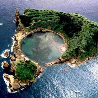
Vila Franca do Campo
|
|
|
Vila Franca do Campo is a town and municipality in the southern part of the island of São Miguel in the Portuguese Autonomous Region of the Azores. The population of the municipality was 11,229 in 2011. The town proper, which incorporates the urbanized parishes São Miguel and São Pedro, has 4100 inhabitants.
Vila Franca do Campo Municipality is located east of Ponta Delgada via the Regional roadway, while it is linked by mountain roads to the eastern and northern communities (including Lagoa, Furnas and Povoação). Most of the mountainous areas of the municipality are forested, interspersed with pasturelands and fields dedicated to agriculture and grazing.
The climate in this region is mild and humid, with temperatures oscillating between 14 °C (57 °F) and 22 °C (72 °F), and with regular precipitation, responsible for the fertile soils and ravines. These ravines that cross the municipality include the Ribeira da s Três Voltas, Ribeira da Praia and Ribeira da Mãe d'Água.
The relief of this region is characterized by basaltic rock and projectiles from volcanic activities on the island, forming many of the distinctive geomorphological structures, such as: the islet of Vila Franca, Pico d'El-Rei (674 m), Monte Escuro (890 m), Lombados Pisões (258 m), Miradouro (685 m), Lagoa do Fogo and Ponta da Pirâmide.
 Feel free to Email me any additions or corrections Feel free to Email me any additions or corrections
LINKS AVAILABLE TO YOUR SITE
| | |
