Lerwick :- Muddy inlet or bay
Lerwick is the capital and main port of the Shetland Islands, Scotland, located more than 100 miles (160 km) off the north coast of mainland Scotland on the east coast of the Shetland Mainland. Lerwick is about 210 miles (340 km) north of Aberdeen, 230 miles (370 km) west of Bergen in Norway and 230 miles (370 km) south east of Torshavn in the Faroe Islands.
Lerwick, Shetland's only burgh, had a population of about 7,500 residents in 2010 and is the most northerly and most easterly town in Scotland (there are other large settlements more northerly in Shetland, most notable the village of Brae).
One of the UK's coastal weather stations is located at Lerwick.
Evidence of human settlement in the Lerwick area dates back 3,000 years, centred around the Broch of Clickimin, which was constructed in the first century BC.
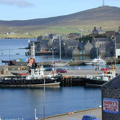
The first settlement to be known as Lerwick was founded in the 17th century as a herring and white fish seaport to trade with the Dutch fishing fleet. This settlement was on the mainland (west) side of Bressay Sound, a natural harbour with south and north entrances between the Shetland mainland and the island of Bressay.
This collection of wooden huts was burned to the ground twice: once in the 17th century by the residents of Scalloway, then the capital of Shetland, who disapproved of the immoral and drunken activities of the assembled fishermen and sailors; and again in 1702 by the French fleet.
Fort Charlotte was built in the mid 17th Century on Lerwick’s waterfront, and permanent stone-built buildings began to be erected around the fort and along the shoreline. The principal concentration of buildings was in the "lanes" area: a steep hillside stretching from the shoreline to Hillhead at the top.
Lerwick became capital of Shetland Islands in 1708. When Lerwick became more prosperous through sea trade and the fishing industry during the 19th century, the town expanded to the west of Hillhead. Lerwick Town Hall was built during this period of expansion.
The next period of significant expansion was during the North Sea oil boom of the 1970s when large housing developments were built to the north of Staney Hill (located in Lerwick) and to the south (Nederdale and Sandveien).