
Like us on Facebook
PLACE NAMES


|
| Gavar |
 |
|
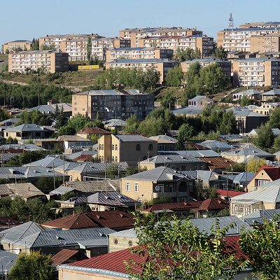
Gavar is a town in Armenia serving as the administrative centre of the Gavar Municipality and the Gegharkunik Province. It is situated among the high mountains of Gegham range to the west of Lake Sevan, with an average height of 1982 meters above sea level. Located 98 kilometers east of the capital Yerevan, the town had a population of 20,765 as per the 2011 census. As per the 2016 official estimate, the population of Gavar is 19,500.
The modern town of Gavar was founded as Novo-Bayazet (New Bayazit) in 1830 around 8 km (5.0 mi) west of the Lake Sevan, on the site of the ancient city of Gavar or Gyavar, following the immigration of 8,557 Armenians from the town of Bayazit (historically known as Daroynk and Arshakavan) of the Ottoman Empire due to the Russo-Turkish war of 1828-1829. The settlement achieved the status of a town in 1850.
However, the area of modern-day Gavar has been inhabited since the Bronze Age. Many historical tombstones, dating back to the 2nd millennium BC are founded in Gavar. The remains of a cyclopean fort dating back to the early Iron Age, are found on a hill at the centre of the town. It is believed that the fortress was the royal capital of the Uelikuhi region within the Urartu kingdom. It was surrounded with more than 22 minor fortifications. The region of Uelikuhi was conquered by the Urartian king Sarduri II. His son, Rusa II renamed the fortress in honour of Khaldi; one of the three chief deities of Ararat. Gavar was known as the “City of Khaldi” while the nearby village of Tsovinar was known as the "City of Teisheba." Urartian cuneiform inscriptions of Rusa II commemorating his victory over the kings of Uelikuhi and establishing the fortress of Khaldi in 732 BC were discovered in 1927, and are now held in the city’s history museum. The Artsvakar neighbourhood of Gavar is also home to another Iron Age fortress, dating back to the 2nd millennium BC.
After the establishment of the ancient Kingdom of Armenia, the territory of modern-day Gavar was included within the Gegharkunik canton at the north of the historic Syunik province of Armenia Major.
Many other ancient and medieval monuments, including monasteries, Khachkars (cross-stones), cuneiform inscriptions, gravestones and a chapel are also found in the town. The Hatsarat neighbourhood (a separate village until the 1960s) is home to the Hatsarat Monastery with 2 churches dating back to the 7th and 19th centuries.
Over the centuries, the area of modern-day Gavar had been severely destroyed, with the latest taking place during the 17th century, when it was ruined by Shah Abbas I of Persia. During the period of Iranian Armenia, Gavar was the center of the Gökcha mahal of the Erivan Khanate.
In 1828, after the Russo-Persian War, the region of Gegharkunik-as a part of the Erivan Khanate—was handed over to the Russian Empire as a result of the Treaty of Turkmenchay signed on 21 February 1828. In 1830, the Armenian migrants from Bayazit founded the village of Novo-Bayazet. With the establishment of the Erivan Governorate in 1850, Novo-Bayazet became the centre of the newly formed Nor Bayazet uezd.
Novo-Bayazet, along with many other regions of Eastern Armenia became part of the USSR in December 1920. After achieving the status of an urban-type settlement in 1950, the town has gradually grown over the years. In 1959, the town was known as Kamo, named after the Bolshevik revolutionary Kamo. It was once home to 36,400 people at the beginning of the 1980s.
After the independence of Armenia in, the town was renamed Gavar in 1995 and became the provincial centre of the newly established Gegharkunik Province. However, much of the Soviet-era infrastructure of the town has failed and the industrial capacity has floundered. As a result, the population of Gavar has drastically declined to 23,302 as reported in the 2001 census, and later to 20,765 as reported in the 2011 census.
|
 Feel free to Email me any additions or corrections Feel free to Email me any additions or corrections
LINKS AVAILABLE TO YOUR SITE
| |
