
Like us on Facebook
PLACE NAMES


|
|
Hemel Hempstead
|
| |
|
Hemel Hempstead is a town in Hertfordshire, England, United Kingdom with a population of 81,143 at the United Kingdom Census 2001 (but now estimated at around 89,000 by Hertfordshire County Council). Developed after World War II as a new town, it has existed as a settlement since the 8th century. It is part of the district (and borough since 1984) of Dacorum and the Hemel Hempstead constituency.
On December 11, 2005 it was in the news for the Hertfordshire Oil Storage Terminal fire (sometimes called Buncefield Blast).
Hemel Hempstead grew up in a shallow chalkland valley at the confluence of the rivers Gade and Bulbourne, 27 miles (43 km) north-west of central London.
The main railway line between London Euston and the Midlands passes through Apsley and Hemel Hempstead railway stations a mile south of the town centre, as does the Grand Union Canal. These links, as well as the A41 trunk road, follow the course of the Bulbourne river valley. The New Town expansion took place up the valley sides and on to the plateau above the original Old Town. In the 1990s, a motorway-style bypass numbered A41 was built to the south and west of the town across the upland chalk plateau, which does not follow the lie of the land. Hemel Hempstead is also linked to the M1 motorway to the east. The M25 is a few miles to the south. To the north and west lie mixed farm and woodland with scattered villages, part of the Chiltern Hills. To the northwest lies Berkhamsted. To the south lies Watford and the beginnings of the Greater London conurbation. To the east lies St Albans, a historic cathedral and market town and now like Hemel Hempstead, part of the London commuter belt. Possibly the best view of Hemel Hempstead in its physical setting is from the top of Roughdown Common, a chalk hill to the south of the town, at TL 049 055.
Remains of Roman villa farming settlements have been found at Boxmoor and Gadebridge which span the entire period of Roman Britain.
The first recorded mention of the town is the grant of land at Hamaele by Offa, King of Essex, to the Saxon Bishop of London in AD 705.
Hemel Hempstead on its present site is mentioned in the Domesday Book of 1086 as a vill, Hamelhamstede, with about 100 inhabitants. The parish church of St Mary's was built in 1140, and is recognised as one of the finest Norman parish churches in the county. The church features an unusual 200 feet (61 m) tall spire, added in the 12th century, one of Europe's tallest.
After the Norman conquest the land thereabouts was given to Robert, Count of Mortain, the elder half-brother of William the Conqueror, as part of the lands associated with Berkhamsted Castle. The estates passed through many hands over the next few centuries including Thomas Becket in 1162. In 1290 King John of England's grandson, the Earl of Cornwall, gave the manor to the religious order of the Bonhommes when he endowed the monastery at Ashridge. The town remained part of the monastery's estates until the Reformation and break-up of Ashridge in 1539.
In that same year the town was granted a Royal charter by King Henry VIII to become a Bailiwick with the right to hold a Thursday market and a fair on Corpus Christi Day. The first Bailiff of Hemel Hempstead was William Stephyns (29 December 1539). The King and Anne Boleyn are reputed to have stayed in the town at this time.
Unusually fine medieval wall paintings from the period between 1470 and 1500 were discovered in some cottages in Piccotts End, very close to Hemel Hempstead in 1953. This same building had been converted into the first cottage hospital providing free medical services by Sir Astley Cooper in 1827.
In 1581, a group of local people acquired lands - now referred to as Box Moor - from the Earl of Leicester to prevent their enclosure. These were transferred to trustees in 1594. These have been used for public grazing and they are administered by the Box Moor Trust.
Hemel's position on the shortest route between London and the industrial Midlands put it on the Sparrows Herne turnpike Toll road in 1762, the Grand Junction Canal in 1795 and the London and Birmingham Railway in 1837. However it remained principally an agricultural market town throughout the 19th century. In the last decades of that century development of houses and villas for London commuters began. The Midland Railway built a branch line connecting to its mainline at Harpenden in 1877 (see The Nicky Line). Hemel steadily expanded, but only became a borough on 13 July 1898. During World War II 90 high explosive bombs dropped on the town by the Luftwaffe. The most major incident was on 10 May 1942 when a stick of bombs demolished houses at Nash Mills killing 8 people. The nearby Dickinson factories which were used to produce munitions and were the target.
After World War II, in 1946, the government designated Hemel Hempstead as the site of one of its proposed New Towns designed to house the London Blitz displaced population of London where slums and bombsites were being cleared. On 4 February 1947 the Government purchased 5,910 acres (23.9 km2) of land and began work on the "New Town". The first new residents moved in during April 1949 and the town continued its planned expansion through to the end of the 1980s. Hemel grew to its present population of 80,000, with new developments enveloping the original town on all sides. The original part of Hemel is still known as the "Old Town".
Its geographical position, between London and the Midlands, acted again in the 1960s when the M1 motorway was routed just to the east of the town. This gave it a central position on the country's motorway network.
In the 1970s, the government abolished the Borough of Hemel Hempstead and the town was incorporated into Dacorum District Council along with Tring and Berkhamsted. The first chairman of that council was Chairman John Johnson (1913-1977). In the 1980s, Dacorum District Council successfully lobbied to be recognised as the successor for the Royal Charter establishing the Borough of Hemel Hempstead and thus regained the Mayor and its Aldermen and became Dacorum Borough Council. The political atmosphere of the town has changed significantly. Once a Labour Party stronghold, the town has seen an increase in Conservative Party voting in recent years, and the current Member of Parliament, Mike Penning, is Conservative.
As of the 2001 census, Hemel Hempstead is the most populated urban area in Hertfordshire, narrowly more populated than its traditionally "larger" rival, Watford.
There was a major explosion in the town at the Hertfordshire Oil Storage Terminal, Buncefield at 6am on Sunday 11 December 2005. This was one of the largest explosions ever to occur in the UK, and the incident has been described as the biggest of its kind in peacetime Europe. The Maylands Avenue industrial estate was severely damaged and much of it needed to be demolished. Nearby residential districts of Adeyfield, Woodhall Farm and Leverstock Green were also badly damaged and around 300 people made temporarily homeless. There were 41 people with minor injuries and two were seriously hurt. The only reason that no one was killed was because the explosion occurred before dawn on a Sunday.
Hemel Hempstead was announced as candidate No 3. for a New Town in July 1946, in accordance with the government's "policy for the decentralisation of persons and industry from London". Initially there was much resistance and hostility to the plan from locals, especially when it was revealed that any development would be carried out not by the local council but by a newly appointed government body, the Hemel Hempstead Development Corporation (later amalgamated with similar bodies to form the Commission for New Towns). However, following a public inquiry the following year, the town got the go-ahead. Hemel officially became a New Town on 4 February 1947.
The initial plans for the New Town were drawn up by architect G. A. Jellicoe. His view of Hemel Hempstead, he said, was “not a city in a garden, but a city in a park.” However the plans were not well-received by most locals. Revised, and less radical plans were drawn up, and the first developments proceeded despite local protests in July 1948. The first area to be developed was Adeyfield. At this time the plans for a double "magic" roundabout at Moor End were first put forward, but in fact it was not until 1973 that the roundabout was opened as it was originally designed. The first houses erected as part of the New Town plan were in Longlands, Adeyfield, and went up in the spring of 1949. The first new residents moved in early 1950.
At this time, work started on building new factories and industrial areas, to avoid the town becoming a dormitory town. The first factory was erected in 1950 in Maylands Avenue. As building progressed with continuing local opposition, the town was becoming increasingly popular with those moving in from areas of north London. By the end of 1951, there was a waiting list of about 10,000 wishing to move to Hemel. The neighbourhoods of Bennett's End, Chaulden and Warner's End were started. The Queen paid a visit shortly after her accession in 1952, and laid a foundation stone for a new church in Adeyfield - one of her first public engagements as Queen. The shopping square she visited is named Queen's Square, and the nearby area has street names commemorating the recent conquest of Everest, such as Hilary and Tenzing Road.
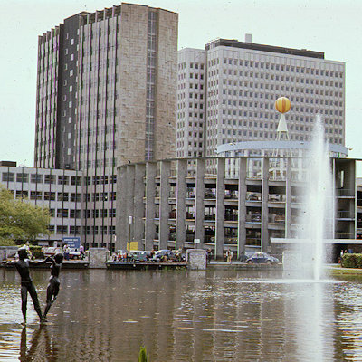
The redevelopment of the town centre was started in 1952, with a new centre based on Marlowes south of the old town. This was alongside a green area called the Water Gardens, designed by Jellico, formed by ponding back the River Gade. The old centre of the High Street was to remain largely undeveloped, though the market square closed and was replaced by a much larger one in the new centre. The former private estate of Gadebridge was opened up as a public park. New schools and roads were built to serve the expanding new neighbourhoods. New housing technology such as prefabrication started to be used from the mid-50s, and house building rates increased dramatically. Highfield was the next neighbourhood to be constructed. The M1 motorway opened to the east in 1959, and a new road connecting it to the town was opened.
By 1962, the redevelopment of the new town as originally envisaged was largely complete, though further expansion plans were then put forward. The nearby United States Air Force base of Bovingdon, which had served as the town's de facto airport, closed at this time, though private flying continued for a further seven years. Dacorum College, the library, new Police station and the Pavilion (theatre and music venue) were all built during the 1960s. The town seemed to attract its fair share of celebrity openings, with shops and businesses opened by Frankie Vaughan, Benny Hill, Terry-Thomas, and the new cinema was opened by Hollywood star Lauren Bacall. The last of the originally-planned neighbourhoods, Grovehill, began construction in 1967. However, further neighbourhoods of Woodhall Farm and Fields End were later built as part of the extended plans.
Like other first generation new towns, Hemel is divided into residential neighbourhoods, each with their own "village centre" with shops, pubs and services. Each neighbourhood is designed around a few major feeder roads with many smaller cul-de-sacs and crescents, intended to minimise traffic and noise nuisance. In keeping with the optimism of the early postwar years, much of the town features modernist architecture with many unusual and experimental designs for housing. Not all of these have stood the test of time.
Historically, the area was agricultural and was noted for its rich cereal production. The agricultural journalist William Cobbett noted of Hemel Hempstead in 1822 that "..the land along here is very fine: a red tenacious flinty loam upon a bed of chalk at a yard or two beneath, which, in my opinion, is the very best corn land that we have in England." By the 18th century the grain market in Hemel was one of the largest in the country. In 1797 there were 11 watermills working in the vicinity of the town.
The chalk on which Hemel is largely built has had commercial value and has been mined and exploited to improve farmland and for building from the 18th century. In the Highbarns area, now residential, there was a collapse in 2007 of a section of old chalk workings and geological studies have been undertaken to show the extent of these workings.
In the 19th century, Hemel was a noted brickmaking, paper manufacturing and straw-plaiting centre. In later nineteenth and early twentieth centuries, Hemel was also a noted watercress growing area, supplying 1/16th of the country's national demand - following development of the New Town, the watercress growing moved to nearby Berkhamsted and Tring. The cress beds were redeveloped as the modern-day Water Gardens.
Joseph Cranstone's engineering company was founded in 1798, and was responsible for much of the early street lighting in the town as well as it first gasworks. It became the Hemel Hempstead Engineering Company and stayed in business until World War II . In 1867 Cranstone's son built a steam powered coach which he drove to London, but which was destroyed in a crash on the return journey. A local Boxmoor pub commemorates the event.
In 1803 the first automatic papermaking machinery was developed in Hemel by the Fourdrinier brothers at Frogmore. Paper making expanded in the vicinity in the early nineteenth century and grew into the huge John Dickinson mills in the twentieth.
A traditional employer in the area was also Brock's, manufacturer of fireworks. The factory was a significant employer since well before World War II, and remained in production until the mid-1970s. The present-day neighbourhood of Woodhall farm was subsequently built on the site.
Hemel is famous (or perhaps notorious) for its "Magic Roundabout" (officially called the Moor End roundabout, or "The Plough Roundabout" from a former adjacent public house), an interchange at the end of the new town (Moor End), where traffic from six routes meet. Traffic is able to circulate in both directions around what appears to be a main central roundabout (and formerly was such), with the normal rules applying at each of the six mini-roundabouts encircling this central reservation. It is a misconception that the traffic flows the 'wrong' way around the inner roundabout; as it is not in fact a roundabout at all, and as such no roundabout rules apply to it. It was the first such circulation system in Britain.
Hemel claims to have the first purpose built multi-storey car park in Britain. Built in 1960 into the side of a hill in the Marlowes shopping district, it features a giant humorous mosaic map of the area by the artist Rowland Emett.
The new town centre is laid out alongside landscaped gardens and water features formed from the River Gade known as the Watergardens designed by G.A. Jellicoe. The main shopping street, Marlowes, was pedestrianised in the early 1990s.
Hemel also was home of one of the first community based television stations West Herts TV which later became Channel 10.
For many years the lower end of Marlowes featured a distinctive office building built as a bridge-like structure straddling the main road. This building was erected on the site of an earlier railway viaduct carrying the Hemel to Harpenden railway, known as The Nicky Line. When the new town was constructed, this part of the railway was no longer in use and the viaduct demolished. The office building, occupied by BP, was designed to create a similar skyline and effect as the viaduct. In the early 1980s it was discovered that the building was subsiding dangerously and it was subsequently vacated and demolished. Adjacent to BP buildings was a unique double-helix public car park. The lower end of Marlowes was redeveloped into the Riverside shopping complex, which opened on 27 October 2005. Retailers taking residence at the Riverside complex, include Debenhams and HMV.
A few hundred metres away, overlooking the 'Magic Roundabout', is Hemel's tallest building; the 19-storey Kodak building. Built as the Kodak company's UK HQ the tower was vacated in 2005. It was then temporarily reoccupied in 2006 after the Buncefield explosion destroyed Kodaks other Hemel offices. It is now being converted into 434 apartment homes.
The Heathrow airport holding area known as the Bovingdon stack lies just west of the town. On a clear day, at peak times, several circling aircraft can be visible.
The national headquarters of the Boys' Brigade is located at Felden Lodge, near Hemel.
A series of 10m high blue steel arches called the Phoenix Gateway has been installed on the roundabout closest to the Hemel Hempstead junction of the M1 motorway. The aim is to regenerate the town after the Buncefield explosion with a striking piece of commercial art. It is Funded by the East of England Development Agency.
|
 Feel free to Email me any additions or corrections Feel free to Email me any additions or corrections
LINKS AVAILABLE TO YOUR SITE
| |

