
Like us on Facebook
PLACE NAMES


|
|
Pevensey
|
 |
|
|
Pevensey - Originally, this was simply a Roman forst called Anderita and, for a time after the Romans departed, as Andredesceaster. But by, the name had changed to Pefenesea - the island in Pefen's River.
The village of Pevensey is located on a ridge of land, which juts out onto marshland. Until the 13th century the marshes were an inlet of the sea, extending inland as far north as Hailsham and eastwards to Hooe; it was studded with small areas of high land which became islands at high tide: and having the place-names - in addition to Peven's sey - of Rickney, Horse Eye, and North Eye. All are derived from the Old English word "eye" meaning island.
With the effect of longshore drift this large bay was gradually cut off from the sea by shingle, so that today's marshes are all that remain behind the shingle beach.
The marshes, known as the Pevensey Levels, cover an area of around 47 miles² (120 km²). They are a Site of Special Scientific Interest and a large nature reserve, jointly owned by Natural England and the Sussex Wildlife Trust. There are many nationally rare plants and invertebrates, including the fen raft spider. The site is very fragile and general access is not permitted.
The settlement of Pevensey Bay lies behind and on the shingle beach. Although small, it is nevertheless a seaside resort in miniature, and has many of the facilities of its larger counterparts elsewhere.
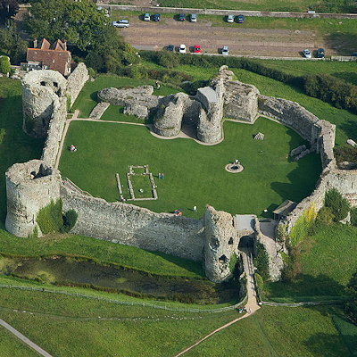
By the 4th century the south and east of the province of Britannia was under frequent attack from marauding barbarian tribes: including the Jutes and Saxons. To counter these attacks the Romans built a total of eleven forts between Essex and the Isle of Wight, now known as the Saxon Shore Forts. The fort at Pevensey, built between 300-340 CE was named Anderitum. The sea washed over what is now Pevensey Marshes, surrounding the fort on three sides.
When the Roman army left Britain, the province was more vulnerable to attack, first by the Jutes in east Kent, and the Romanised native Britons attempted to defend their island from attack. Following the Jutish example the Saxons began invading Britain in earnest. Around 491, Saxons, possibly lead by Aelle of Sussex began to colonise the south coast and besieged Anderitum over a number of years. After a long struggle the British defences were overrun. The remaining Britons on the south coast either fled north into the forests or by boat over the channel to what is now called Brittany. The area became the Kingdom of the South Saxons - later called Sussex - and the old Roman fort of Anderida was burned and left derelict. For a while the ruined castle was known by the Saxons as Andredceaster and the Weald of southern England - which stretches 120 miles (200 km) from Anderida to Dorset - was named Andredsweald or the Forest of Andred.
The dereliction and abandonment of the fort continued. Then, in 1042, Harold Godwinson, later Harold II of England, established a stronghold here, improving fortifications by digging ditches within the walls of the fort. The English army remained at the fort during the summer of 1066 before abandoning it to meet the invading Norwegians further north.
The earliest stone remains on the site date from the Roman period, including the outer bailey wall.
When William the Conqueror invaded Sussex in September 1066 there were no defenders at Pevensey, and the still-existing bay provided a safe haven for the invading fleet.
In late 1066 the Roman fort at Pevensey was occupied by the Normans; much of the Roman stonework still existing today is due largely to the work of Robert, Count of Mortain (half brother to William), who was granted Pevensey Castle shortly after the Norman Conquest. Robert de Mortain used the remains as the base for building his castle, carrying out only minor repairs to the walls forming the outer bailey, and building a new inner bailey at the eastern end.
The castle was besieged several times during the 11th-13th centuries. An order by Queen Elizabeth I that it be demolished and an attempt at demolition during the Puritan times were both unsuccessful: the order was ignored and only a few stones were removed on the two occasions. As late as 1942 small additions were made to the castle for the defence of Britain, when it became a lookout over the channel for German aircraft during World War II.
Today the castle is in the upkeep of English Heritage.
In the 16th century Pevensey became what was known as a "non-corporate limb" of the Hastings, as part of the Confederation of the Cinque Ports. Along with most of the other Ports, its importance dwindled as the ports themselves became disconnected from the sea: Pevensey was two miles (3.2 km) distant.
During the 18th and 19th centuries Pevensey Bay became involved in the south coast smuggling trade, since it was one of the easier places to land the contraband. In 1833 a violent clash occurred between the smugglers and customs men at Pevensey Bay.
Some of the more than 100 Martello towers were erected along the beaches of Pevensey Bay at the beginning of the 19th century against Napoleonic attack.
|
 Feel free to Email me any additions or corrections Feel free to Email me any additions or corrections
LINKS AVAILABLE TO YOUR SITE
| |

