
Like us on Facebook
PLACE NAMES


|
|
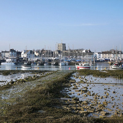
Shoreham-by-Sea
|
 |
|
 | The Dome, 22a Marine Parade, Worthing - 01903 221066
10 Bartholomew Square, Brighton - 01273 290337/292599
tic@adur-worthing.gov.uk
|
Old Shoreham dates back to pre-Roman times. St Nicolas' Church, inland by the River Adur, is partly Anglo-Saxon The name of the town has an Old English origin. The town and port of New Shoreham was established by the Norman conquerors towards the end of the 11th century.
St Mary de Haura Church (St Mary of the Haven) was built in the decade following 1103 (the Domesday Book was dated 1086), and around this time the town was laid out on a grid pattern that, in essence, survives in the town centre. The church is only half the size of the original - the former nave was ruinous at the time of the civil war although remnants of the original west façade survive in the churchyard to some height.
Muslim scholar Muhammad al-Idrisi, writing c.1153, described Shoreham as "a fine and cultivated city containing buildings and flourishing activity".
The growth of neighbouring Brighton, Hove and Worthing - in particular the arrival of the railway in 1840 - prepared the way for Shoreham's rise as a Victorian sea port, with several shipyards and an active coasting trade. Shoreham Harbour remains in commercial operation to this day.
Southdown Golf Club, Shoreham-by-Sea was founded in 1902, but ceased to operate in the 1940s.
Shoreham Beach, to the south of the town, is a shingle spit deposited over millennia by longshore drift, as an extension to Lancing parish in the west. This blocks the southerly flow of the River Adur which turns east at this point to discharge into the English Channel further along the coast at a point that has varied considerably over time. During the 17th and 18th centuries, the mouth of the river shifted eastwards which restricted trade to the port; by 1810 it was almost opposite Aldrington church. In 1816, work had been completed to fix the position of the river in its present position, flowing into the sea between two piers. Once the harbour mouth was stabilised it was defended by Shoreham Fort which was built in 1857.
Converted railway carriages became summer homes around the start of the 20th century, and 'Bungalow Town', as it was then known, became home to the early British film industry. Shoreham Beach officially became part of Shoreham-by-Sea in 1910. Much of the housing in the area was cleared for defence reasons during the Second World War and most of what remained after the war is now long gone, having been replaced by modern houses, some of which are extremely expensive, architect designed constructions. The Church of the Good Shepherd, built in 1913, still stands. Along the Adur mud flats adjacent to Shoreham Beach sits (and at high tides floats) a large collection of houseboats made from converted barges, tugs, mine sweepers,[9] Motor Torpedo Boats etc. The seaside shingle bank of Shoreham beach extends further east past the harbour mouth, forming the southern boundary of the commercial harbour in Southwick, Portslade and Hove. The Monarch's Way long-distance footpath, commemorating the flight of Charles II to France after the Battle of Worcester, follows the beach westwards from Hove past Portslade and Southwick, terminating by the harbour mouth's east breakwater.
Transversed by the River Adur and with the downs and the sea nearby the area supports a diverse wildlife flora and fauna. The mudflats support wading birds and gulls, including the ringed plover which attempts to breed on the coastal shingle.[citation needed] The pied wagtail is common in the town in the winter months. Insects include dragonflies over the flood plains of the river. The south and west facing downs attract at least 33 species of butterflies including a nationally important population of the chalkhill blue butterfly on Mill Hill. The underlying rock is chalk on the downs, with alluvium in the old river channels. The Adur district has a variety of habitats in a small area, including natural chalk downs and butterfly meadows, freshwater and reed beds, salt marsh and estuary, brackish water lagoons, woodland, shingle seashore, chalk platform undersea and large expanses of sand.
|
 Feel free to Email me any additions or corrections Feel free to Email me any additions or corrections
LINKS AVAILABLE TO YOUR SITE
| |
