
Like us on Facebook
PLACE NAMES


|
|
Vercors National Park
|
| |
 |
255 Chem. des Fusillés, Lans-en-Vercors. - +33 476 943826
email withheld

|
The Vercors Regional Natural Park (French: Parc naturel régional du Vercors) is a protected area of forested mountains in the Rhône-Alpes region of southeastern France.
Set upon a limestone plateau south of Grenoble, the park extends into the French Western Alps. It spans two departments, Drôme and Isère, and covers a total area of 135,000 hectares (330,000 acres).
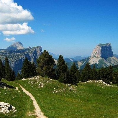
The Vercors Massif is a roughly triangular-shaped plateau with a maximum north–south length of 60 kilometres (37 mi) and a maximum width of 40 kilometres (25 mi). The lowlands surrounding the steep-sided plateau average about 250 metres (820 ft) in elevation above sea level while the top of the massif has an average elevation of about 1,000 metres (3,300 ft) with a maximum elevation of 2,341 metres (7,680 ft) at Grand Veymont. Unlike a flat-topped mesa, three ridges run along the top of the massif from north to south. Only a few roads climb the steep slopes to access the massif and the population lives in a few small villages. The porous limestone rocks and karst terrain result in an extensive system of caves and caverns and a scarcity of surface water in the form of streams, springs, and shallow wells. These characteristics would be important during the battle as the Germans took control of the water sources and ambushed maquis seeking water.
The Vercors area is peppered with caves. During World War II, it served as a safe and defensible position for the French Resistance: Forteresse de la Résistance. The area now contains around three hundred monuments to the Resistance, including a memorial center and the preserved remains of a destroyed village.
In modern times, Vercors has become a popular tourist destination frequented for skiing, hiking and spelunking. Several small communes dot the landscape, supported principally by forestry, shepherding and tourism. The area was officially designated a regional natural park in 1970.
Mont Aiguille is at the southern end of the north-to-south ridge.
 Feel free to Email me any additions or corrections Feel free to Email me any additions or corrections
LINKS AVAILABLE TO YOUR SITE
| | |
