
Like us on Facebook
PLACE NAMES


|
|
Mont-St-Michel
|
|
|
|
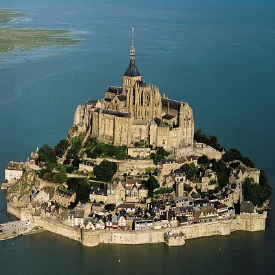
Mont Saint-Michel is an island commune in Normandy, France. It is located approximately one kilometre (0.6 miles) off the country's northwestern coast, at the mouth of the Couesnon River near Avranches. 100 hectares (247 acres) in size, the island has a population of 44 (2009).
The island has held strategic fortifications since ancient times, and since the eighth century CE has been the seat of the monastery from which it draws its name. The structural composition of the town exemplifies the feudal society that constructed it: On top, God, the abbey and monastery; below this, the great halls; then stores and housing; and at the bottom, outside the walls, fishermen's and farmers' housing.
Its unique position of being an island only 600 metres from land made it readily accessible on low tide to the many pilgrims to its abbey. Equally, this position made it readily defensible as an incoming tide stranded, or drowned, would-be assailants. By capitalising on this natural defence, the Mont remained unconquered during the Hundred Years' War with a small garrison successfully defending it against a full attack by the English in 1433. The reverse benefits of its natural defence was not lost on Louis XI who turned The Mont into a state prison and thereafter the abbey started to be used more regularly as a jail during the Ancien Régime from the sixteenth century.
One of France's most recognisable landmarks, Mont Saint-Michel and its bay are part of the UNESCO list of World Heritage Sites and more than 3 million people visit it each year.
Now a rocky tidal island, in prehistoric times the Mont was on dry land. As sea levels rose, erosion reshaped the coastal landscape, and several outcroppings of granite or granulite emerged in the bay, having resisted the wear and tear of the ocean better than the surrounding rocks. These included Lillemer, the Mont-Dol, Tombelaine (the island just to the north), and Mont Tombe, later called Mont Saint-Michel. The Mont has a circumference of about 960 metres (3,150 ft), and is 92 metres (302 ft) above sea level at its highest point.
 Feel free to Email me any additions or corrections Feel free to Email me any additions or corrections
LINKS AVAILABLE TO YOUR SITE
| | |

