
Like us on Facebook
PLACE NAMES


|
|
Flers
|
|
|
|
Flers is bordered to the north by the communes of Saint-Georges-des-Groseillers and Aubusson, to the north-east by Ronfeugerai, to the west by La Lande-Patry and Saint-Paul, to the south-west by La Chapelle-Biche, La Chapelle-au-Moine and Messei, and to the south-east by La Selle-la-Forge.
The commune is situated in the north-west of the Orne departement, about ten kilometres from the border of the Calvados, an hour east of Granville, and two hours by train from Paris. It depends on a prefecture located an hour north in Caen.
The commune is crossed by the river Vère which ends in the river Noireau in Pont-Erembourg.
Flers is part of the region that stretches from the Bocage to the Écouves forest, the wettest part of the Orne departement, with relatively mild temperatures thanks to its proximity to the English Channel and the effect of the sea. It benefits from an oceanic climate with mild winters and temperate summers.
The first written mentions of Flers appear at the end of the twelfth century as Flers (1164-1179) or Flex (1188-1221). Some authors think that the name of the town derives from the German toponym Hlaeri, meaning wasteland or common grazing land, while others suggest an origin in the German Fliessen, from the Dutch vliet or the Latin fluere latin Fluere, indicating a waterflow, basin or marsh. Yet another etymology links Flers to the Latin flexus, meaning the bend in a road or river. Finally, the Breton term fler or flear means bad smell, indicating the stench of stagnant water. All etymologies seem to agree however that the town is named for its topography and the water close to it.
From the tenth century on, the de Flers family headed a barony. Tradition has it that in the 11th century, the two brothers Foulques d'Aunou and Guillaume de Gasprée married two sisters who were Ladies of Flers. Foulques d'Aunou received as his wedding gift Flers, seat of the barony.
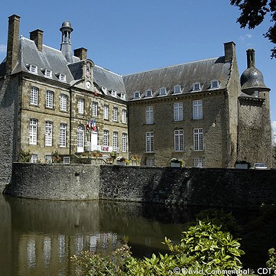
The construction of the castle of Flers began in the 12th century as a fortified location of wood and stone surrounded by water. The chronicles of the Hundred Years War do not mention a fortified place in Flers, revealing that it didn't present a major strategic interest at the time.
In 1790, in the revolutionary period, Flers formed a canton in the district of Domfront, in the Orne departement. The countess of Flers, Jacqueline Le Goué de Richemont, wife of Pierre-François de Paule de La Motte-Ango, supported the counter-revolutionary chouans. The castle of Flers became the headquarters of count Louis de Frotté, one of the leaders of the Normandic Chouannerie.
In 1901, Julien Salles, mayor of Flers, bought the castle for the community.
Like other towns near the D-Day landing, Flers was one of the targets of strategic bombing of Normandy on 6 and 7 June 1944, aimed at reducing the advance of German reinforcements. 80% of the town was destroyed. What remained of the town was liberated on 16 August by the British 11th Armoured Division (United Kingdom) and the memorial to the division is at Pont de Vère, north of Flers.
 Feel free to Email me any additions or corrections Feel free to Email me any additions or corrections
LINKS AVAILABLE TO YOUR SITE
| | |

