
Like us on Facebook
PLACE NAMES


|
|
Braga
|
|
|
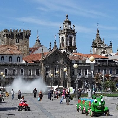
Braga is a city and a municipality in the northwestern Portuguese district of Braga, in the historical and cultural Minho Province. The city has a resident population of 192,494 inhabitants (in 2011), representing the seventh largest municipality in Portugal (by population). Its agglomerated urban area extends from the Cávado River to the Este River. It is the third-largest urban centre in Portugal (after Lisbon and Porto).
It is host to the oldest Portuguese archdiocese, the Archdiocese of Braga of the Catholic Church and it is the seat of the Primacy of the Spains. Under the Roman Empire, then known as Bracara Augusta, the settlement was the capital of the province of Gallaecia. Inside of the city there is also a castle tower that can be visited. Nowadays, Braga is a major hub for inland Northern Portugal and it is an important stop on the Portuguese Way path of the Road of St James. The city was also the European Youth Capital in 2012.
Situated in the heart of Minho, Braga is located in a transitional region between the east and west: between mountains, forests, grand valleys, plains and fields, constructing natural spaces, moulded by human intervention. Geographically, with an area of 184 square kilometres (71 sq mi) it is bordered in the north by the municipalities of Vila Verde and Amares, northeast and east by Póvoa de Lanhoso, south and southeast with Guimarâes and Vila Nova de Famalicão and west by the municipality of Barcelos.
The topography in the municipality is characterized by irregular valleys, interspersed by mountainous spaces, fed by rivers running in parallel with the principal rivers. In the north it is limited by the Cávado River, in the south by terrain of the Serra dos Picos to a height of 566 metres (1,857 ft) and towards the east by the Serra dos Carvalhos to a height of 479 metres (1,572 ft), opening to the municipalities of Vila Nova de Famalicão and Barcelos. The territory extends from the northeast to southwest, accompanying the valleys of the two rivers, fed by many of its tributaries, forming small platforms between 20 metres (66 ft) and 570 metres (1,870 ft).
The municipality lies between 20 metres (66 ft) and 572 metres (1,877 ft), with the urbanized centre located at approximately 215 metres (705 ft). In the north, where the municipality is marked by the Cavado, the terrain is semi-planar, the east is mountainous owing to the Serra do Carvalho 479 metres (1,572 ft), Serra dos Picos 566 metres (1,857 ft), Monte do Sameiro 572 metres (1,877 ft) and Monte de Santa Marta 562 metres (1,844 ft). Between the Serra do Carvalho and Serra dos Picos is the River Este, forming the valley of Vale d'Este. Similarly, between the Serra dos Picos and Monte do Sameiro exists the plateau of Sobreposta-Pedralva. To the south and west, the terrain is a mix of mountains, plateaus and medium-size valleys, permitting the passage of the River Este, and giving birth to other confluences including the River Veiga, River Labriosca and various ravines.
 Feel free to Email me any additions or corrections Feel free to Email me any additions or corrections
LINKS AVAILABLE TO YOUR SITE
| | |
