
Like us on Facebook
PLACE NAMES


|
|
Santa Eulalia del Rio
|
|
|
|
Santa Eulària des Riu is a coastal town on the south eastern seaboard of the Spanish island of Ibiza. The town is located on the designated road PM 810. Santa Eulària is the third largest town on the island and also has the only river on the island which flows into the sea at the western end of the town.
The town is 9.3 miles (15.0 km) north east of Ibiza Town and 13.6 miles (21.9 km) of Ibiza Airport. The town sits next to a wide bay with the promontory of Punta Arabí at the east end of the Bay. Also at the eastern end of the bay is new harbour, mariner called Port Esportiu which is full of restaurants, shops and bars. The town has two beaches which are kept clean and tidy and have gently sloping sands and are ideal for young families. At the western end of the bay is the prominent hill of 'Puig d'en Fita' which dominates the landscape. The hill is dotted with apartments, hotels and private houses, and at night is dotted with the dwellings lights.
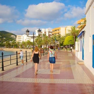
At the centre of the town on the 'Plaça d'Espanya' is the Ajuntament (town hall) which is now one of the last historical buildings of the town. The present building, which has been renovated, dates from 1795 and reflects the typical architecture of the period on the island. Nowadays the building is less functional as a town hall and is used with a civic representative purpose. In front of the Ajuntament is a small square which has a fountain with a stone surround which faces the busy main street of '[Carrer Saint Jaume'. Behind the fountain is a stone monument, erected by the city of Palma, Mallorca to thank and honour the local fishermen who, On 17 January 1913, rescued victims of the shipwrecked steamboat 'Mallorca' which had run aground on a reef near the rocky inlet of Redona at Punta Arabí. The town streets run grid like from the 'Plaça d'Espanya' with the 'Carrer Saint Jaume' running west to east. The 'Carrer da Sant Vincent' runs parallel, one street back from 'Carrer Saint Jaume' with the western end of 'Plaça d'Espanya'. This street is pedestrianized and is filled with typical Tavernas and restaurants. There are also one or two lively bars. The 'Carrer Saint Jaume' is full of stores, banks, bars and restaurants. The 'Passeig de s'Alamera' is an attractive thoroughfare which runs south from the 'Plaça d'Espanya' down to the seafront. This boulevard has a tree lined central pedestrianized area with gardens. In the summer this shady 'Ramblas' is lined with market stalls selling jewellery, sarongs, tie-dye Thai garb and trinkets of all kinds. At the southern end of 'Passeig de s'Alamera' is Santa Eulalia's harbour front with views of the bay. Running in either direction is a paved and landscaped promenade. Below the promenade are the resorts two sandy beaches which have safe designated bathing areas which in the season are patrolled by lifeguards. Behind the promenade the bay is ringed by concrete apartment blocks, some of which have shops, bars, café and restaurants opening on to the promenade.
The river is called Riu de Santa Eulalia, it is more of a small stream and only ever becomes a raging torrent following very heavy rainfall. The source of the river is below the 342-metre-high Puig d'en Sopes close to Sant Miquel. The river then meanders for 17 kilometres (11 mi) through the countryside to the sea at the western end of the town. A small way inland from the mouth of the river there is a small triple arched bridge, the Pont Vell, the bridge crosses the rocky valley and is claimed to have been built by the Romans as part of the imperial road building schemes on the island between 200 BC and AD 400, although the bridge's earliest mention is in a document of 1720. The river is also the only one of its kind in the Balearic Islands, and is fed by several small tributaries, notably the Torrent de Labritja, which originates at the northern village of Sant Joan de Labritja.
|
 Feel free to Email me any additions or corrections Feel free to Email me any additions or corrections
LINKS AVAILABLE TO YOUR SITE
| | |

