Like us on Facebook
PLACE NAMES


|
|
Ashford
|

| |
|
Ashford is a town in the borough of Ashford in Kent. In 2005 it was voted the fourth best place to live in the United Kingdom. It lies on the River Great Stour, M20 motorway, South Eastern Main Line and High Speed railways. Its agricultural market is one of the most important in the county.
Ashford is listed in the Domesday Book, compiled in 1086, as having a church, two mills and a value of 150 shillings, under its original Saxon name of "Essetesford" (or "Eshetisford," "Esselesford", "Asshatisforde", "Essheford"). The manor was owned by Hugh de Montford, Constable of England at the time. Writer Philpot believed Essetesford stood for "ash trees growing near a ford", while Lampard, a 16th century local historian, suggested that it meant "a ford over the river Eshe or Eshet", which was the old name for the tributary of the River Stour between Lenham and Ashford.
The motto for Ashford is "With stronger faith", taken from, To Lucasta, Going to the Warres, a poem by the 17th century poet Richard Lovelace from the borough, the relevant verse being.
"True, a new mistress now I chase,
The first foe in the field;
And with a stronger faith embrace
A sword, a horse, a shield."
As a market town, Ashford has for centuries been a local communications hub for surrounding villages and has stood at the centre of five railway lines, (Ashford to Ramsgate (via Canterbury West) line, Swanley to Ashford (via Maidstone East) Line, South Eastern Main Line, Kent Coast Line and the Marshlink Line) since the 19th century and with the opening of the International Passenger Station is now an important European communications centre, with new lines running between London and the Channel Tunnel.
The Borough of Ashford lies on the eastern edge of the ancient forest of "Andredsweald" or "Anderida". This originally stretched as far west as Hampshire and formed the basis from which the Weald is formed.
It is likely that the town originates from an original settlement established in 893AD by inhabitants escaping a Danish Viking raid on the nearby ancient village of Great Chart (Seleberhtes Cert in 762AD), although a Roman road passed through here from the iron making area to Canterbury.
Its closeness to London has always made Kent a strong influence on the capital, and vice versa. Thus by the end of the 16th century Cade (of Cade's Rebellion) was credited by William Shakespeare in Henry VI, part 2 as being from Ashford. The play includes an Ashford butcher called "Dick" who looks forward to removing officialdom after the rebellion and says: first thing, let's kill all the lawyers.
Ashford's importance as a growing agricultural and market town was confirmed in 1243 when it was incorporated, and by the end of the 16th century it had risen to become an important market town, primarily for livestock. The market was held in the High Street until 1856 when local farmers and businessmen relocated to Elwick Road and formed a market company that claims to be the oldest surviving registered company in England and Wales. There is still a regular street market in the town, although the market company has relocated outside the town and is used by some 5,000 farmers.
Parts of the parish church date from the 13th century but was substantially restored in the 15th century with many alterations since. In 1638 a free grammar school was founded here, it was built on the churchyard’s west side, and remained there until 1846, now used as a museum.
During World War II Ashford's importance as a transportation (railway) hub and its location between the Continent and London made it a target for bombing by the Luftwaffe.
The Joint Services School of Intelligence was based at Templar Barracks in Ashford, until the barracks were decommissioned in 1997 and then demolished to make way for High Speed Rail Link. In 1982, Prince Andrew, Duke of York was involved with the "School".
Ashford lies in a valley at the confluence of the Rivers Upper Great Stour and East Stour, where the River Great Stour is formed and turns northwards to go through the Stour Gap in the North Downs towards Canterbury, Sandwich, and the English Channel. To the south lies the Weald.
The original town of Ashford, in common with most such towns, has outgrown its original size and has combined with smaller villages in a conurbation. These villages include Bockhanger, Kennington, Sevington, Singleton, and Willesborough. In addition, housing estates have been built in the open spaces amongst Bybrook, Godinton, Kingsnorth, Park Farm, and Stanhope.
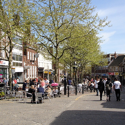
Essentially a modern town, little is left of the old Ashford town centre, apart from some mediaeval half-timbered buildings in Middle Row and around the churchyard in the town centre. A number of old buildings were removed to make way for the controversial ring road around the centre, built in the early 1970s. Three modern shopping centres are located in the town: Park Mall, County Square, and the new Designer Outlet. Bank Street and High Street are traffic-free shopping thoroughfares.
The increase in the town's commercial importance, as well as its strategic location, is witnessed by the number of industry, business, and retail parks in the town. These include Waterbrook, a 740,000-m² (183-acre) site for production, storage and distribution with a freight clearance facility; Eureka Science and Business Park, including manufacturing sites and prestige office complexes; the 570,000-m² (141-acres) Orbital Park; the Ashford Designer Outlet shopping centre, which has won a design award; and fourteen other business parks and industrial estates. There is also a factory of Campbell Soup UK producing Batchelor's Soup.
The 2007 Kent earthquake, which registered 4.3 on the Richter scale, was felt in Ashford, though its effects were greatest in Folkestone.
 Feel free to Email me any additions or corrections Feel free to Email me any additions or corrections
LINKS AVAILABLE TO YOUR SITE
| | |


