
Like us on Facebook
PLACE NAMES


|
|
Dover
|
| |
|
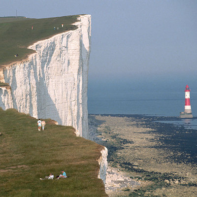
Dover is a town and major ferry port in the home county of Kent, in South East England. It faces France across the narrowest part of the English Channel, and lies south-east of Canterbury; west of Kent's administrative capital Maidstone; and north-east along the coastline from Dungeness and Hastings. The town is the administrative centre of the Dover District, home of the Dover Calais ferry through the Port of Dover, and the point where the Channel tunnel makes landfall. The surrounding chalk cliffs have become known as the White cliffs of Dover, and the narrow sea passage nearby - the Strait of Dover.
Its strategic position has always been evident throughout its history: archaeological finds have revealed that the area has always been a focus for peoples entering and leaving Britain. The River Dour originated the name of the town, which has been inhabited since the Stone Age according to archeological finds, and Dover is one of only a few places in Britain – London, Cornwall and Canterbury being other examples – to have a corresponding name in the French language, Douvres.
Services related to the Port of Dover provide a great deal of the town’s employment, as does tourism, although many of the former ferry services have declined. There was a military barracks in Dover, which was closed in 2007.
In the 4th century BC, the Greek astronomer Pytheas assured his colleagues that he could calculate the latitude of a strange island off the coast of Gaul which seafarers had sung songs about. Setting sail, he arrived here and, passing by the cliffs at Dover, declared this to be Albion the "White Land". His calculation turned out to be correct within a smal margin. The Romans called it ’’Porte Dubris’’; the modern name was in use at least by the time Shakespeare wrote 'King Lear' (between 1603 and 1606), in which the town and its cliffs play a prominent role.
Dover’s history, because of its proximity to France, has always been of great strategic importance to Britain. Archaeological finds have shown that there were Stone Age people in the area; and that by the Bronze Age the maritime influence was already strong. Some Iron Age finds exist also, but the coming of the Romans made Dover part of their communications network. Like Lemanis (Lympne) and Rutupiae (Richborough) Dover was connected by road to Canterbury and Watling Street; and it became Portus Dubris, a fortified port. Forts were built above the port; lighthouses were constructed to guide ships; and one of the best-preserved Roman villas in Britain is here.
Dover figured largely in the Domesday Book as an important borough. It also served as a bastion against various attackers: notably the French during the Napoleonic Wars; and against Germany during World War II.
Dover is near the extreme south-east corner of Britain. At South Foreland, the nearest point to the continent, Cap Gris Nez near Calais is 34 kilometres (21 mi) away, across the Strait of Dover.
The site of its original settlement lies in the valley of the River Dour, making it an ideal place for a port, sheltered from the prevailing south-westerly winds. This led to the silting up of the river mouth by the action of longshore drift; the town was then forced into making artificial breakwaters to keep the port in being. These breakwaters have been extended and adapted so that the port lies almost entirely on reclaimed land.
The higher land on either side of the valley - the Western Heights and the eastern high point on which Dover Castle stands - has been adapted to perform the function of protection against invaders. The town has gradually extended up the river valley, encompassing several villages in doing so. Little growth is possible along the coast, since the cliffs are on the sea’s edge. The railway, being tunnelled and embanked, skirts the foot of the cliffs.
|
 Feel free to Email me any additions or corrections Feel free to Email me any additions or corrections
LINKS AVAILABLE TO YOUR SITE
| |

