
Like us on Facebook
PLACE NAMES


|
|
Dudley
|
 |
|
 | Dudley Library, St James's Road, Dudley - 01384 812830
39 Churchhill Centre, Dudley -
tourism@dudley.gov.uk
|

In Domesday, it was Dudelei. From the Old English leah (clearing) where Dudda lived.
Dudley has a history dating back to medieval times. Dudley Castle has stood on a hill overlooking the town since the 11th century, and is mentioned in the Domesday Book. The present castle dates from the 13th century, and provided the centre around which the town grew. Dating from the 12th century are the ruins of St James Priory, set within the Priory Park.
Dudley CastleThe town industrialised rapidly in the 18th and 19th centuries, and its population grew dramatically. Due to its heavy and highly polluting industries it became a central part of the Black Country. The main industries in Dudley included coal and limestone mining. Other industries included iron, steel, engineering, metallurgy, glass cutting, textiles and leatherworking. Most of these industries have declined in recent decades.
Of historical significance, the first Newcomen steam engine was installed at the Conygree coalworks a mile east of Dudley Castle in 1712.
Dudley was a predominantly rural town as recently as the early 18th century, after which the Industrial Revolution saw many factories and coalpits open up around the town as well as houses for the workers to live in were being built. Further development took place in the 19th century.
However, many of the houses built for industrial workers in Dudley were in a sub standard condition by the turn of the 20th century and mass demolition of the town centre slums began in the 1920s, accelerating in the 1930s. The occupants of the slums were rehoused on modern council housing developments including the large Priory and Wren's Nest housing estates as well as smaller developments in areas such as Woodside and Kates Hill. Substantial private housing was built at this time as well.
During World War II, Dudley was bombed on several occasions, with a number of fatalities, though nowhere near as severely as its near neighbour Birmingham.
The first major council housing development was the Priory Estate, where more than 2,000 houses were built between 1929 and 1939. The Wrens Nest Estate followed soon afterwards. It stands in the shadow of Wrens Nest Hill, where many Silurian fossils can be found including crinoids, corals and trilobites.
The Castle Hill area of the town was heavily developed for entertainment attractions in the first 40 years of the 20th century. An Opera House was opened there in 1899, followed a year later by the Station Hotel (rebuilt in the 1930s) opposite. The Opera House was destroyed by fire in December 1936 and replaced by a Plaza cinema. By this stage, a Hippodrome Theatre opened next door. An Odeon cinema opened on the opposite side of the road at around the same. However, the postwar decline in cinema and theatre attendance - brought on by the rising popularity of home television - affected the area greatly. The Hippodrome closed in 1966, and has been used for several purposes - most recently by Gala Bingo. The Plaza closed in 1990 and was briefly used as a Laser Quest laserdome until its demolition in 1997.
After the war was over, thousands of sub standard properties remained, and the clearance and rehousing continued in the 1950s and was almost complete by the early 1960s. The postwar years saw the development of further new council housing estates including Russells Hall and Old Park Farm. The 1960s saw the construction of 11 multi storey blocks of council flats in Dudley - the tallest three of them at Eve Hill, and smaller blocks at Grange Park, Queens Cross and Netherton.
The nearby village of Lower Gornal was the epicentre for the Dudley earthquake of 2002, the largest earthquake to hit the United Kingdom in nearly 10 years.
The town centre is a mix of old and modern buildings, with some surviving from as far back as the 18th century, while others were built in the second half of the 20th century. Modern shopping developments include the Churchill Shopping Preicint (opened in 1969 and named after the late prime minister Sir Winston Churchill who died four years earlier) and the indoor Trident Centre which opened around the same time. The Churchill Shopping Preicint was originally an open-air centre owned and run by the local council, only to be sold to a private company in 1991 - within two years a substantial refurishment of the preicint had been completed, which included a roof being fitted.
Most of the town's multiple stores were situated on Market Place and High Street. However, the development of the Merry Hill Shopping Centre four miles away at Brierley Hill during the second half of the 1980s saw most of the multiple stores (including Marks and Spencer and British Home Stores) relocate from Dudley and predominantly replaced by discount stores. The financial crisis and recession which has hit Britain and most of the rest of the world since 2007 has resulted in many of the retail units in Dudley town centre becoming vacant. The Woolworths store on Market Place closed in December 2008 when the company went bankrupt, and has been replaced by an indoor market, though few of the other stores which became vacant around the same time have been reoccupied.
By the end of the thirteenth century, Dudley had become a manorial borough. Before 1791, Dudley was governed by the Court Leet of the Lords of Dudley. Between 1791 and 1852, the Town Commissioners were the principal local authority. The Town Commissioners were superseded in 1853 by the Board of Health. Dudley became a municipal borough in 1865. In 1889, it became a County Borough. The County Borough of Dudley included the town of Dudley and the villages of Woodside and Netherton. In the 1961 census, the County Borough had a population of 62,965.
Dudley's Council House in Priory Road was opened in 1935 by King George V. It was financed by the then Earl of Dudley, William Humble Eric Ward, who stipulated that when the Mayor is seated at the head of the council chamber he should have a direct line of sight to Dudley Castle once all the chamber doors are thrown open (Source: 'Dudley's Little Book of Big History', Dudley MBC publication, 2008)
In 1966, the county borough was expanded to include the majority of the urban district councils of Brierley Hill and Sedgley, about half of Coseley along with small areas of Amblecote and Rowley Regis, as well as a fragment of rural Seisdon. As the majority of these areas were part of Staffordshire, Dudley was transferred from Worcestershire to the county of Staffordshire. Part of the Oakham area of the town was transferred into Warley County Borough. These changes meant that the population of Dudley County Borough at the time of the 1971 census increased to 185,592; an increase of almost 300% from the 1961 figure.
Dudley's borough boundaries were further expanded in 1974 to become a Metropolitan Borough, having taken in the boroughs of Halesowen and Stourbridge (both formerly in Worcestershire). This meant a further increase in population, which by the time of the 1981 census was 298,511 - an increase of five times the population of only twenty years before.
Since 1974, Dudley has been part of the West Midlands county.
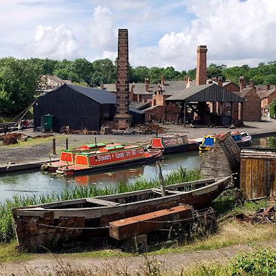
The town is home to Dudley Zoo, and the Black Country Living Museum. Visitors to the museum may also take a narrowboat trip from the adjacent canal, through the Dudley Tunnel. The ruined Dudley Castle is within the grounds of the zoo, and there is an extensive wooded ridge that runs north from the castle. Dudley Zoo is to be regenerated under proposals by Dudley Zoo in partnership with Dudley Council, St Modwen and Advantage West Midlands, which will see a former freightliner site redeveloped with a tropical dome, Asiatic forest, two aquatic facilities and walkthrough aviaries.
Dudley is home to a former Odeon Cinema and a former music hall, the Dudley Hippodrome, both from the Art Deco period in the 1930s. The Dudley Hippodrome was built on to the side of the now-demolished Opera House (built in 1900 and burnt down in 1936) and is now a bingo hall. There is a Showcase Cinema in a retail park between the zoo and museum.
The Odeon Cinema became an Assembly Hall for the Jehovah's Witnesses in 1976 for the West Midlands Area.
The Plaza Cinema was built on Castle Hill in 1938 next to the Hippodrome, and remained open until October 1990. The building was then taken over by Laser Quest, who used it until it was demolished in 1997. The site of the cinema remains undeveloped.
Since the 1970s, there has been a nightclub on Castle Hill situated on the corner of Station Drive; this has changed ownership several times since first opening.
There are many canals in and around Dudley, the main one being the Dudley Canal - most of which passes beneath Dudley in a tunnel which lacks a towpath and is therefore accessible only by boat.
The open sections of canal are popular with walkers, cyclists, fishermen, and narrowboat users. Many of the canalside towpaths have been upgraded for cycling, and some sections are part of the National Cycle Network.
The Wren's Nest National Nature Reserve is a site of special scientific interest (SSSI) considered to be one of the most notable geological locations in the British Isles and home to the Calymene blumenbachi trilobite nicknamed the Dudley Bug or Dudley Locust by 18th century quarrymen. Dudley Museum and Art Gallery has a large collection of its well-preserved Silurian coral reef fossils, plus numerous displays relating to the history of the town.
Established in 1260, Dudley Market in Dudley town centre is a major shopping area for the town. It has undergone numerous developments in its history. One major development was in 1982 when the area was pedestrianised and the 12th century cobblestones were removed. Other developments have included the addition of a new roof and new toilet facilities, with the new ground level block having replaced underground toilets in the early 1990s.
Dudley is also the location of several churches. These include the Church of St. Edmund, Church of St. James, and Church of St. Thomas.
The old St Edmund's Church School, a 19th century building near the town centre, was closed in 1970 on a merger with St John's Church School on Kates Hill, and later converted into a mosque for the town's growing Islamic community, which is mostly concentrated around Kates Hill, Queen's Cross, Eve Hill and The Buffery.
St James's Church at Eve Hill also had a church school from the mid 19th century, but this was closed during the 1970s and was used as a community centre for several years before being transferred to the Black Country Museum in 1989. The site of the school remained vacant until 2008, when work began on a new health centre that is due to open by 2010.
|
 Feel free to Email me any additions or corrections Feel free to Email me any additions or corrections
LINKS AVAILABLE TO YOUR SITE
| |
