
Like us on Facebook
PLACE NAMES


|
|
Avebury
|
 |
|
 | Bank House, The Strand, Calne - 01249 814000
The Library, High Street, Marlborough - 01672 513989
calne@calne.gov.uk
|
The name of the village of Avebury and the earthwork have been synonymous only since the 20th century. The earliest written mention of the earthwork is from the 13th century, when it is referred to as "Waledich". In 1696, it was referred to as Wallditch. Both names are of Anglo-Saxon origin, and probably mean "ditch of the wealas"; wealas was a term used by Anglo-Saxon colonists to describe an enclave of native Britons. Neo-Druids call the site Caer Abiri.
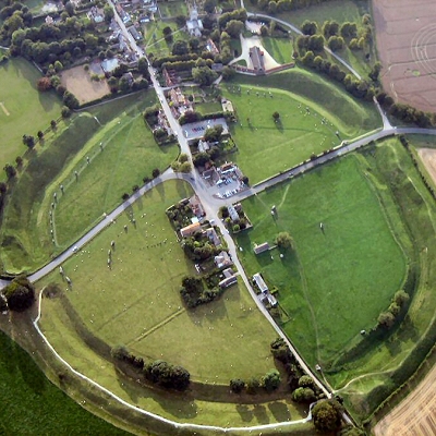
Avebury is the site of a large henge and several stone circles surrounding the village of Avebury in the English county of Wiltshire. It is one of the finest and largest Neolithic monuments in Europe, about 5,000 years old. Although older than the megalithic stages of Stonehenge 32 kilometres (20 mi) to the south, the two monuments are broadly contemporary overall. Avebury is roughly midway between the towns of Marlborough and Calne, just off the main A4 road on the northbound A4361 towards Wroughton. The henge is a Scheduled Ancient Monument and a World Heritage Site.
Avebury is respectively about 6 and 7 mi (10 and 11 km) from the modern towns of Marlborough and Calne. Avebury lies in an area of chalkland in the Upper Kennet Valley at the western end of the Berkshire Downs that forms the catchment for the River Kennet with local springs and seasonal watercourses. The monument stands slightly above the local landscape, sitting on a low chalk ridge 160 m (520 ft) above sea level; to the east are the Marlborough Downs, an area of lowland hills. The site lies at the centre of a collection of Neolithic and early Bronze Age monuments and was inscribed as a World Heritage Site in a co-listing with the monuments at Stonehenge, 17 mi (27 km) to the south, in 1986. It is now listed as part of the Stonehenge, Avebury and Associated Sites World Heritage Site. The monuments are preserved as part of a Neolithic and Bronze Age landscape for the information they provide regarding prehistoric people's relationship with the landscape.
Radiocarbon dating and analysis of pollen in buried soils, has shown that the environment of lowland Britain changed around 4,250-4,000 BC. The change to a grassland environment from damp, heavy soils and expanses of dense forest was mostly brought about by farmers, probably through the use of slash and burn techniques. Environmental factors may also have made a contribution. Pollen is poorly preserved in the chalky soils found around Avebury, so the best evidence for the state of local environment at any time in the past comes from the study of the deposition of snail shells; different species of snail live in specific habitats so the presence of a certain species indicates what the area was like at a particular point in time. The available evidence suggests that in the early Neolithic, Avebury and the surrounding hills were covered in dense oak woodland, and as the Neolithic progressed, the woodland around Avebury and the nearby monuments receded and was replaced by grassland.
The history of the site prior to the construction of the henge is uncertain due to a lack of dating evidence from modern archaeological excavations. Evidence of activity in the region before the 4th millennium BC is limited, indicating that there was little occupation. Stray finds of flints at Avebury, dating between 7,000 and 4,000 BC, indicate that the site was visited in the late Mesolithic period by hunter-gatherers, however, a collection of flints found 300 m (980 ft) to the west of Avebury marks the site of a flint working site occupied over several weeks. Avebury's later importance, despite minimal earlier activity, was not unique; sites which follow this pattern include Stonehenge in Wiltshire and Hambledon Hill in Dorset. Another possible parallel with Stonehenge is the presence of a posthole, similarly shaped to one at Stonehenge, near Avebury's southern entrance. Although this has not been dated, archaeologists Mark Gillings and Joshua Pollard believe that the position of the posthole, which is incongruous with the rest of the henge, indicates it probably dates to a pre-henge phase.
In the 4th millennium BC, around the start of the Neolithic period in Britain, society in Britain underwent radical changes. These coincided with the introduction of domesticated species of both animals and plants to Britain and a changing material culture - new objects such as pottery have been found from this period. This domestication allowed hunter-gatherers to settle down and provide their own food. As agriculture spread, the people cleared land. Also, for the first time, monuments were erected, which has been taken as evidence of people's changing the way they viewed their place in the world.
Based on anthropological studies of modern societies, Gillings and Pollard suggest that forests, clearings, and stones were important in Neolithic culture, not only as resources but symbolically; the site of Avebury was at a convergence of these three elements. Neolithic activity at Avebury is evidenced by flint, animal bones, and pottery such as Peterborough ware dating from the early 4th and 3rd millennia BC. There are also five distinct areas of Neolithic activity within 500 m (1,600 ft) of Avebury; this includes a scatter of flints along the line of the West Kennet Avenue - an avenue that connects Avebury with the Neolithic site of The Sanctuary. Pollard suggests that areas of activity in the Neolithic became important markers in the landscape.
The construction of large monuments such as Avebury indicates that a stable agrarian economy had developed in Britain by around 4,000-3,500 BC. The people who built them had to be secure enough to spend time on such non-essential activities. Avebury was one of a group of monuments built in the area in the Neolithic period. The monuments comprise a henge (Avebury) and associated long barrows, stone circles, avenues, and a causewayed enclosure. These types of monument are not exclusive to the Avebury area; for example: Stonehenge features the same monument types, and in Dorset there is a henge on the edge of Dorchester and nearby a causewayed enclosure at Maiden Castle. According to Caroline Malone, who worked for English Heritage as an inspector of monuments and was the curator of Avebury's Alexander Keiller Museum, it is possible that the monuments associated with Avebury - and other Neolithic monumental landscapes such as Stonehenge - constituted ritual or ceremonial centres.
Most of the surviving structure is composed of earthworks, known as the dykes, consisting of a massive ditch and external bank henge. Although the henge is not perfectly circular, it has a diameter of about 420 metres (460 yd). The only known comparable sites of similar date are only a quarter of the size of Avebury. The ditch alone was 21 metres (69 ft) wide and 11 metres (36 ft) deep, with a sample from its primary fill carbon dated to 3300 - 2630 BC (4300+/-90). The excavation of the bank has demonstrated that it has been enlarged, presumably using material dug from the ditch, so it could be assumed that the construction of the ditch could have started at the earlier date, although speculation puts it nearer the later date.
Within the henge is a great outer circle. This is one of Europe's largest stone circles, with a diameter of 335 metres (1,099 ft). It was either contemporary with, or built around four or five centuries after the earthworks. There were originally 98 sarsen standing stones, some weighing in excess of 40 tons. The stones varied in height from 3.6 to 4.2 m, as exemplified at the north and south entrances. The fill from two of the stoneholes has been carbon dated to between 2900 and 2600 BC.
Nearer the middle of the monument are two additional, separate stone circles. The northern inner ring is 98 metres (322 ft) in diameter, but only two of its four standing stones remain upright. A cove of three stones stood in the middle, its entrance facing northeast.
The southern inner ring was 108 metres (354 ft) in diameter before its destruction in the eighteenth century. The remaining sections of its arc now lie beneath the village buildings. A single large monolith, 5.5 metres (18 ft) high, stood in the centre along with an alignment of smaller stones.
The West Kennet Avenue, an avenue of paired stones, leads from the southeastern entrance of the henge; and traces of a second, the Beckhampton Avenue, lead out from the western entrance.
Archaeologist Aubrey Burl has conjectured a sequence of construction beginning with the erection of the North and South Circles around 2800 BC, followed by the Outer Circle and henge around two hundred years later, with the two avenues added around 2400 BC.
Findings of archaeological geophysics suggests that a timber circle of two concentric rings stood in the northeast sector of the outer circle. This has not yet been confirmed by excavation. A ploughed barrow is visible from the air in the northwestern quadrant.
The henge had four opposing entrances, two on a north by northwest and south by southeast line, and two on an east by northeast and west by southwest line.
Many of the original stones were broken up or removed from the early 14th century onwards at the behest of the Christian Church to remove association with pagan rituals, to make room for agriculture, or to provide local building materials. Both John Aubrey and later, William Stukeley visited the site and described the destruction. When Aubrey first arrived in 1643, all the stones of the Avenue were either still in situ or lying where they had fallen. Shortly afterward the systematic destruction of the stones began in earnest; some were broken up by being hammered and others by being heated in large fires and broken along a line marked with water. Stukeley spent much of the 1720s recording what remained of Avebury and the surrounding monuments, and left a drawing depicting the fire and water method. He was greatly angered by the destruction of the monument, writing:
And this stupendous fabric, which for some thousands of years, had brav'd the continual assaults of weather, and by the nature of it, when left to itself, like the pyramids of Egypt, would have lasted as long as the globe, hath fallen a sacrifice to the wretched ignorance and avarice of a little village unluckily plac'd within it.
Only 27 stones of the Outer Circle survive, many of them re-erected by Alexander Keiller in the 1930s. Concrete pylons now mark the former locations of the missing stones. It is likely that more stones are buried on the site.
Excavation at Avebury has been limited. In 1894 Sir Henry Meux put a trench through the bank, which gave the first indication that the earthwork was built in two phases. The site was surveyed and excavated intermittently between 1908 and 1922 by a team of workmen under the direction of Harold St George Gray. He was able to demonstrate that the Avebury builders had dug down 11 metres (36 ft) into the natural chalk using red deer antlers as their primary digging tool, producing a henge ditch with a 9-metre (30 ft) high bank around its perimeter. Gray recorded the base of the ditch as being 4 metres (13 ft) wide and flat, but later archaeologists have questioned his use of untrained labour to excavate the ditch and suggested that its form may have been different. Gray found few artefacts in the ditch-fill but he did recover scattered human bones, amongst which jawbones were particularly well represented. At a depth of about 2 metres (7 ft), Gray found the complete skeleton of a 1.5-metre (5 ft) tall woman.
During the 1930s archaeologist Alexander Keiller re-erected many of the stones. Under one, now known as the Barber Stone, the skeleton of a man was discovered. Coins dating from the 1320s were found with the skeleton, and the evidence suggests that the man was fatally injured when the stone fell on him whilst he was digging the hole in which it was to be buried in a medieval "rite of destruction". As well as the coins Keiller found a pair of scissors and a lancet, the tools of a barber-surgeon at that time, hence the name given to the stone.
When a new village school was built in 1969 there was a further opportunity to examine the site, and in 1982 an excavation to produce carbon dating material and environmental data was undertaken.
In April 2003, during preparations to straighten some of the stones, one was found to be buried at least 2.1 metres (7 ft) below ground. It was estimated to weigh over 100 tons, making it one of the largest ever found in the UK. Later that year, a geophysics survey of the southeast and northeast quadrants of the circle by the National Trust, revealed at least 15 of the megaliths lying buried. The National Trust were able to identify their sizes, the direction in which they are lying, and where they fitted in the circle.
A great deal of interest surrounds the morphology of the stones, which are usually described as being in one of two categories; tall and slender, or short and squat. This has led to numerous theories relating to the importance of gender in Neolithic Britain with the taller stones considered "male" and the shorter ones "female". The stones were not dressed in any way and may have been chosen for their pleasing natural forms. Many claim to have identified carvings on the stones' surfaces, some carvings being more persuasive than others.
The human bones found by Gray point to some form of funerary purpose and have parallels in the disarticulated human bones often found at earlier causewayed enclosure sites. Ancestor worship on a huge scale could have been one of the purposes of the monument and would not necessarily have been mutually exclusive with any male/female ritual role.
The henge, although clearly forming an imposing boundary to the circle, has no defensive purpose as the ditch is on the inside. Being a henge and stone circle site, astronomical alignments are a common theory to explain the positioning of the stones at Avebury.
The relationships between the causewayed enclosure, Avebury stone circles, and West Kennet Long Barrow to the south, has caused some to describe the area as a "ritual complex" – a site with many monuments of interlocking religious function.
Avebury is seen as a spiritual centre by many who profess beliefs such as Paganism, Wicca, and Druidry; for some it is regarded more highly than Stonehenge. The pagan festivals all attract visitors, and the summer solstice especially draws increasingly large crowds. Avebury is said to stand on the St Michael ley line, an alignment that is said to run across England from Cornwall to East Anglia.
The question of access to the site at certain times of the year has been controversial and The National Trust, who steward and protect the site, have been in dialogue with a number of groups.
The Red Lion public house in Avebury is rumoured to be one of the most haunted pubs in England.
|
 Feel free to Email me any additions or corrections Feel free to Email me any additions or corrections
LINKS AVAILABLE TO YOUR SITE
| |
