
Like us on Facebook
PLACE NAMES


|
|
Wiesbaden |
| |
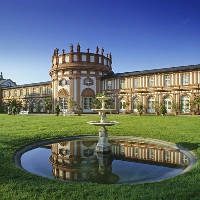
Wiesbaden is a city in central western Germany and the capital of the state of Hesse. As of June 2020, it had 290,955 inhabitants, plus approximately 19,000 United States citizens (mostly associated with the United States Army). The Wiesbaden urban area is home to approx. 560,000 people. Wiesbaden is the second-largest city in Hesse after Frankfurt am Main.
The city, together with nearby Frankfurt am Main, Darmstadt, and Mainz, is part of the Frankfurt Rhine Main Region, a metropolitan area with a combined population of about 5.8 million people.
Wiesbaden is one of the oldest spa towns in Europe. Its name translates to "meadow baths", a reference to its famed hot springs. It is also internationally famous for its architecture and climate-it is also called the "Nice of the North" in reference to the city in France. At one time, Wiesbaden boasted 26 hot springs. As of 2008, fourteen of the springs are still flowing.
In 1970, the town hosted the tenth Hessentag Landesfest (English: Hessian Day, a state festival).
The city is considered the tenth richest in Germany (2014) boasting 110.3% of the national average gross domestic product in 2017.
Wiesbaden is situated on the right (northern) bank of the Rhine, below the confluence of the Main, where the Rhine's main direction changes from north to west. The city is across the Rhine from Mainz, the capital of the state of Rhineland-Palatinate. Frankfurt am Main is located about 38 kilometres (23.6 mi) east. To the north of the city are the Taunus Mountains, which trend in a northeasterly direction.
The city center, the Stadtmitte, is located in the north-easternmost part of the Upper Rhine Valley at the spurs of the Taunus mountains, about 5 kilometres (3.1 mi) from the Rhine. The landscape is formed by a wide lowland between the Taunus heights in the north, the Bierstadter Höhe and the Hainerberg in the east, the Mosbacher Mountain in the south, and the Schiersteiner Mountain in the west, an offshoot of the Taunus range. The downtown is drained only by the narrow valley of the Salzbach, a tributary of the Rhine, on the eastern flanks of the Mosbacher Mountain. The city's main railway line and the Mainz road (Mainzer Straße) follow this valley. Several other streams drain into the Salzbach within the city center: the Wellritzbach, the Kesselbach, the Schwarzbach, the Dambach, and the Tennelbach, as well as the outflow of many thermal and mineral springs in the Kurhaus (spa) district. Above the city center, the Salzbach is better known as the Rambach.
The highest point of the Wiesbaden municipality is located northwest of the city center near the summit of the Hohe Wurzel, with an elevation of 608 metres (1,995 ft) above sea level. The lowest point is the harbour entrance of Schierstein at 83 metres (272 ft) above sea level. The central square (the Schlossplatz, or palace square) is at an elevation of 115 metres (377 ft).
Wiesbaden covers an area of 204 km² (79 sq mi). It is 17.6 kilometres (10.9 mi) from north to south and 19.7 kilometres (12.2 mi) from west to east. In the north are vast forest areas, which cover 27.4% of the urban area. In the west and east are vineyards and agricultural land, which cover 31.1% of the area. Of the municipality's 79 kilometres (49.1 mi)-long border, the Rhine makes up 10.3 kilometres (6.4 mi).
|
 Feel free to Email me any additions or corrections Feel free to Email me any additions or corrections
LINKS AVAILABLE TO YOUR SITE
| | |

