
Like us on Facebook
PLACE NAMES


|
| Chesham
|  |
|
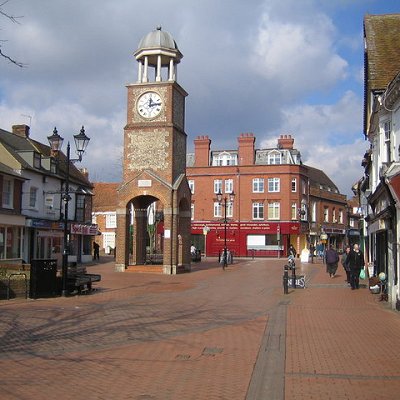
Chesham is a market town and civil parish in Buckinghamshire, England. It is 11 miles (18 km) south-east of the county town of Aylesbury and 25.8 miles (41.5 km) north-west of Charing Cross, central London, and is part of the London commuter belt. It is in the Chess Valley and surrounded by farmland. The earliest records of Chesham as a settlement are from the second half of the 10th century although there is archaeological evidence of people in this area from around 8000 BC. Henry III granted the town a royal charter for a weekly market in 1257.
Chesham is known for its four Bs - boots, beer, brushes and Baptists. In the face of fierce competition from both home and abroad the three traditional industries rapidly declined. The ready availability of skilled labour encouraged new industries to the town both before and after the Second World War. Today, employment in the town is provided mainly by small businesses engaged in light industry, technology and professional services.
From the early part of the 20th century, there has been a considerable expansion with new housing developments and civic infrastructure. Chesham has become a commuter town with improved connection to London via the London Underground and road networks. The town centre has been progressively redeveloped since the 1960s and has been pedestrianised since the 1990s. The population at the 2011 Census was 21,483.
Chesham developed as a market town which prospered through its manufacturing industries fuelled by a series of mills which sprung up along the River Chess. Until the 19th century the town was centred to the south-eastern end of the present High Street. Most of the present-day town centre's development took place during Victorian times. The 'old town', particularly Church and Germain Street, has been well preserved and now designated a conservation area. It includes a number of impressive residential, institutional and commercial buildings that largely survived Victorian 'improvement'. The 12th century St Mary's Church, which underwent refurbishment and redesign by George Gilbert Scott in the 19th century. 'The Bury', a Queen Anne town house was built in 1712 for William Lowndes Secretary to the Treasury. Chesham had two workhouses, both buildings survived and are located in Germain Street. In June 2009 the Chesham town centre and old town conservation area was placed on the English Heritage Conservation Areas at Risk register which the District Council commented was due to the misinterpretation of its responses to the conservation body's questionnaire. Due to the pattern of the town's expansion there are several centres of employment which are interspersed with residential housing. Industrial buildings on the north side of the town have been redeveloped into offices in recent years.
The town had a population of 2,425 by 1841. This had increased to more to 9,000 by the end of the 19th century. As a consequence the centre of the town shifted to the east as shops, workshops and cottages sprung up along the High Street and Berkhampstead Road. In the period after the Second World War the town centre was progressively redeveloped. In the 1960s St Mary's Way was constructed, rerouting the A416 around the congested High Street which avoided the need to widen the street, conserved its character and allowed for its pedestrianisation during the 1990s. Industrial development became centred on two areas. At the southern end of the town at Waterside which was the site of the first mills and factories in the 18th and 19th centuries there is a mixture of original and newly constructed industrial units and at the northern end along the Asheridge Vale there is a further development of generally small commercial business units.
Compared to other towns in south Buckinghamshire, there are fewer detached and owner-occupied houses and a higher proportion of social rental accommodation. Expansion in housing has occurred in several phases mainly to the east of the old town where artisan's housing sprung up along Berkhamsted Road and subsequently along the many steep valley sides. Initially this development was as a consequence of the extension of the railway to the town in the 1880s, subsequently the promotion of Metroland during the 1920s and the electrification of the Metropolitan line in the 1960s. Pond Park estate was built in the 1930s. The population grew fast after the Second World War as workers followed employers who moved out from London. The population in 1951 was 11,500 leading to the building of the Chessmount and Hilltop estates by speculative developers in the 1950s and '60s. By 1971 the population had reached 20,000 since when it has only increased slightly. The growing popularity of the Chilterns as a place to live from the latter part of the 20th century onwards led to restrictions on housing and industrial development in the Chilterns Area of Outstanding Natural Beauty and has sustained the demand for further house building in the town. Today an increasing number of those in employment find work outside the town, commuting by car or train as well as an increasing number who are home or office-based using technology to make a living.
|
 Feel free to Email me any additions or corrections Feel free to Email me any additions or corrections
LINKS AVAILABLE TO YOUR SITE
| | |

