
Like us on Facebook
PLACE NAMES


|
|
Ivybridge
|
| |
|
Ivybridge is a small town and civil parish in the South Hams, in Devon, England. It lies about 9 miles (14.5 km) east of Plymouth. It is at the southern extremity of Dartmoor, a National Park of England and Wales and lies along the A38 "Devon Expressway" road. Ivybridge has a population of 11,851.
Mentioned in documents as early as the 13th century, Ivybridge's early history is marked by its status as an important crossing-point over the River Erme on the Exeter-to-Plymouth route. In the 16th century mills were built using the River Erme's power. The parish of Saint John was formed in 1836. Ivybridge became a civil parish in 1894 and a town in 1977.
The early urbanisation and development of Ivybridge largely coincided with the Industrial Revolution. When the South Devon Railway Company built its train route through Ivybridge in the 19th century a paper mill was constructed alongside it and this led to an increase in housing nearby. The paper mill, now French owned, still provides local jobs. Although occasionally referred to as a dormitory town, many people work in the town itself, and agriculture continues to play an economic role for Ivybridge's hinterland. The area surrounding Ivybridge is almost completely farmland.
When heavy industry diminished during the latter half of the 20th century, the population has boomed (400% in 30 years) from 1,574 people in 1921 to 12,056 in 2001.
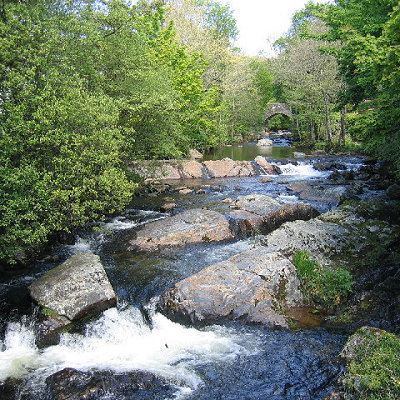
The topography of Ivybridge is generally hilly. This is because of the River Erme which flows right through the centre of town. To the east and to the west of the river the land is elevated forming a valley. The river first enters the town at 90 metres (300 ft) metres above sea level and leaves the town at 40 metres (130 ft) metres above sea level. At its height the top of the east and west of the valley is 80 metres (260 ft) metres above sea level. The western beacon is a hill that overlooks the town; its peak can be seen from almost anywhere in the town. It's 328 metres (1,076 ft) metres above sea level and 278 metres (912 ft) metres above the town. There is also an area of woodland called Longtimber woods to the north of the town, which attracts many walkers along its riverside path.
The geology of Ivybridge is varied. Throughout most of the town the rock is Old Red Sandstone (sedimentary) from the Devonian period.[16] To the north of the town Granite can be found as it is situated on the slopes of Dartmoor – a large pre-volcanic area of Granite. Along the River Erme large boulders and rocks can be found deposited on its meandering path brought all the way from Dartmoor; the Ivy Bridge itself is made out of Granite.
The built environment in and around Ivybridge is mainly characterised by its suburban streets plans and houses, although in the centre of Ivybridge it's mainly characterised by Victorian buildings. From the centre of the town most buildings are terraced and now many of these buildings have been converted into retail outlets along Fore Street – the town's central business district. In the middle layer of the town most buildings are semi-detached and built on quite steep roads. More detached houses are found on the outer layers of the city on the east and on the west of the town. Over the past decades the town has been shaped by its two most essential pieces of infrastructure: the railway line to the north and the A38 dual carriageway to the south. No large scaling housing has been built on either side of these boundaries. Due to this Ivybridge has been forced to grow east and west rather than north and south; it stretches approximately 1.76 miles (2.83 km) from east to west and 1 mile (1.6 km) from north to south.
|
 Feel free to Email me any additions or corrections Feel free to Email me any additions or corrections
LINKS AVAILABLE TO YOUR SITE
| |

