|
Plymouth is a city and unitary authority area on the south coast of Devon, England, about 190 miles (310 km) south-west of London. It is situated between the mouths of the rivers Plym to the east and Tamar to the west, where they join Plymouth Sound. Since 1967, the City of Plymouth has included the suburbs of Plympton and Plymstock, which are situated on the east side of the River Plym.
Plymouth's history goes back to the Bronze Age, when its first settlement grew at Mount Batten. This settlement continued to grow as a trading post for the Roman Empire, until the more prosperous village of Sutton, the current Plymouth, surpassed it. In 1620, the Pilgrim Fathers left Plymouth for the New World and established Plymouth Colony – the second English settlement in what is now the United States of America. During the English Civil War the town was held by the Parliamentarians and was besieged between 1642 and 1646.
Throughout the Industrial Revolution, Plymouth grew as a commercial shipping port, handling imports and passengers from the Americas, while the neighbouring town of Devonport grew as an important Royal Naval shipbuilding and dockyard town. In 1914 the three neighbouring and independent towns, viz., the county borough of Plymouth, the county borough of Devonport, and the urban district of East Stonehouse were merged to form a single County Borough. The new, merged town took the name of Plymouth which, in 1928, achieved city status. The city's naval importance later led to its targeting and partial destruction during World War II, an act known as the Plymouth Blitz. After the war the city centre was completely rebuilt.
Today the city is home to around 250,000 people, making it the 27th most populous built-up area in England and Wales. It is governed locally by Plymouth City Council and is represented nationally by three MPs. Plymouth's economy is still strongly influenced by shipbuilding, but has become a more service-based economy since the 1990s. It has the ninth largest university in the United Kingdom by number of students, the University of Plymouth, and the largest operational naval base in Western Europe – HMNB Devonport. The city has ferry links to France and Spain.
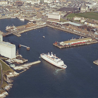
Since 1967, the unitary authority of Plymouth has included the, once independent, towns of Plympton and Plymstock which lie along the east of the River Plym. The River Tamar forms the county boundary between Devon and Cornwall and its estuary forms the Hamoaze on which is sited Devonport Dockyard.
The River Plym, which flows off Dartmoor to the north-east, forms a smaller estuary to the east of the city called Cattewater. Plymouth Sound is protected from the sea by the Plymouth Breakwater, in use since 1814. In the Sound is Drake's Island which is seen from Plymouth Hoe, a flat public area on top of limestone cliffs. The Unitary Authority of Plymouth is 30.8 square miles (80 km²), but the city of Plymouth, as cited from Plymouth City Council, is 30.61 square miles (79.3 km²). The topography rises from sea level to a height, at Roborough, of about 509 feet (155 m) above Ordnance Datum (AOD).
Geologically, Plymouth has a mixture of limestone, Devonian slate, granite and Middle Devonian limestone. Plymouth Sound, Shores and Cliffs is a Site of Special Scientific Interest, because of its geology. The bulk of the city is built upon Upper Devonian slates and shales and the headlands at the entrance to Plymouth Sound are formed of Lower Devonian slates, which can withstand the power of the sea.
A band of Middle Devonian limestone runs west to east from Cremyll to Plymstock including the Hoe. Local limestone may be seen in numerous buildings, walls and pavements throughout Plymouth. To the north and north east of the city is the granite mass of Dartmoor; the granite was mined and exported via Plymouth. Rocks brought down the Tamar from Dartmoor include ores containing tin, copper, tungsten, lead and other minerals. There is evidence that the middle Devonian limestone belt at the south edge of Plymouth and in Plymstock was quarried at West Hoe, Cattedown and Radford.
On 27 April 1944 Sir Patrick Abercrombie's Plan for Plymouth to rebuild the city was published; it called for the demolition of the few remaining pre-War buildings in the city centre and their replacement with wide, modern boulevards aligned east–west linked by a north–south avenue (Armada Way) connecting the railway station and Plymouth Hoe. Prefabs had started to be built by 1946, and over 1,000 permanent council houses were built each year from 1951–57. By 1964 over 20,000 new homes had been built, more than 13,500 of them permanent council homes and 853 built by the Admiralty. Plymouth is home to 28 parks with an average size of 45,638 square metres (491,240 sq ft). Its largest park is Central Park, with other sizeable green spaces including Victoria Park, Freedom Fields Park, Alexandra Park, Devonport Park and the Hoe.
|