|
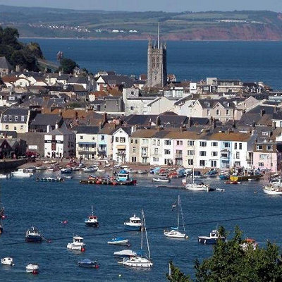
Teignmouth is a town and civil parish in Teignbridge in the English county of Devon, situated on the north bank of the estuary mouth of the River Teign about 14 miles south of Exeter. It has a population of 14,413. In 1690, it was the last place in England to be invaded by a foreign power. The town grew from a fishing port associated with the Newfoundland cod industry to a fashionable resort of some note in Georgian times, with further expansion after the opening of the South Devon Railway in 1846. Today, its port still operates and the town remains a popular seaside holiday location.
The town is located on the north bank of the mouth of the estuary of the River Teign, at the junction of the A379 coast road, the A381 road to Newton Abbot, and the B3192 which climbs up to the A380 on Haldon and hence on to the M5 12 miles away. Teignmouth is linked to Shaldon, the village on the opposite bank, by a passenger ferry at the river mouth and by a road bridge further upstream. The red sandstone headland on the Shaldon side called "The Ness" is the most recognisable symbol of the town from the seaward side.
In the harbour area was the Salty, a small flat island created through dredging operations but levelled, supposedly to improve natural scouring of the main channel for shipping, in recent years to leave a large tidal sand bank frequented by seabirds and cockle-collectors. Salmon nets are still employed by locals, especially near Shaldon Bridge.
The estuary seems disproportionately large for the size of the river flowing through it, this being especially apparent at low tide, because it is a drowned valley caused by a relative rise in sea level following the last Ice Age.
|