Meyrueis is a commune in the Lozère département in southern France.
The town of Meyrueis is located between the foothills of Mount Aigoual to the south, and the Causse Mejean to the north. The town thus marks the border between the geographic areas of the Grand Causses, Causses Noir and Causse Mejean, and the Cevennes Mountains. Three rivers are meeting there : the Jonte, the Bethuson and the Brèze. The communal territory stretches over 10,468 hectares, delimitated by a rectangle of 25 km long and 10 km wide, with an average altitude of 706 meters, and a highlight of 1562 meters.
The neighbouring towns are Saint-Pierre-des-Tripiers and Hures-la-Parade to the north, Gatuzières to the east, Saint-Sauveur-Camprieu and Lanuéjols to the south. Finally, to the south-west, we find the commune of Veyreau in the Aveyron.
Sites and monuments include:
- Old Castle of Meyrueis - A medieval castle of Meyrueis of Carolingian origin was located on the dominant 70-meter rock the city. Seat of a viguerie, which extended from the Causse Méjean to the upper valley of the Hérault River, the castle belonged to the barons of Meyrueis, the youngest branch of the Anduze family, as early as the 10th century. The domain was then owned by a branch of the family Roquefeuil until in 1230 when it passed by marriage to the counts of Rodez, and in 1283 to those of Armagnac, then to the Duke of Alençon, before falling in 1321 to the Albret family. Jeanne d'Albret, Queen of Navarre, bequeathed the castle to his son Henri de Bourbon, who became Henry IV, unites his possessions to the domains of the Crown of France (1607). The castle was repeatedly attacked during the Hundred Years' War by "routiers" (mercenaries) roaming the area. Meyrueis, at that time a Protestant city of Languedoc, was in regular conflict with the young King Louis XIII. The castle lived its last seat in 1628. The Duke Henri de Rohan, military leader of the rebels, laid siege to the castle with several thousand men in May 1628. The castle was held by a garrison loyal to the king and threatened the city in revolt. After three weeks of siege, the 130 soldiers of the Royal Captain Regis capitulated, leaving the castle in the hands of Duke. But this success was short-lived. In 1629, Rohan was defeated and the king sealed peace through the "Grace d'Ales ". This edict, granted in 1630, forgave the rebels but ordered the destruction of their fortifications. The demolition of the castle and the two main gates of the city took place in 1632.
- Chapel of Our Lady of the Rock - The last major remnants of the castle were destroyed in 1875 during the construction of the Chapel of Our Lady of the Rock, which now occupies the site of the fort. This chapel is the subject of two annual pilgrimages, the last Sunday in May and 15 August.
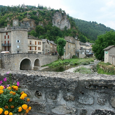
- Remains of fortifications and Clock Tower - The Meyrueis retains vestiges of its fortifications. Two town gates have survived the destruction of 1632. The Méjeane gate (middle) and portal Prieirou (priory) always provide access to the medieval district, called "La Ville", and contains remains of the Jewish Quarter (Judarié), of the first Protestant church (16th century) and the Maison des Consuls on the small square named the "Planet". The clock tower, rebuilt in 1568 on medieval foundations, forms the angle of the fortifications above the confluence of the Jonte and Béthuzon. Restored after a fire in 1897, the tower bears the town clock since the 14th century. The ironwork campanile on the top contains a bell of nice proportions, dated 1634. Purchased for a half by the municipality and the other by the Protestant church, it was used to mark the hours, call the municipal council, give the alarm, and until 1685, call people to worship. It always beats the hours of the city and now houses the tourist office.
- The Roquedols Castle, located 2 km south of the city in the valley of Béthuzon, dates from the first half of the 16th century.
From 1236 Roquedols (Rocadols, Rocadaholis, Repedolsa = soft rock) was a locality with several mas forming a hamlet. But this is probably at the end of the 14th century that the first castle was built by Sir Pagès de Porcarès, who in 1336 took the title of "noble Pierre Pagès". In the mid-16th century, Antoine de Pagès is called Seigneur de Pourcarès and Roquedols. He probably erects the current castle Roquedols, which front door bears the date 1534. Protestant, he would have made worship "in the fashion of Geneva" in his mansion from 1555. His son Herail Pagès joined the Protestant troops in 1560, first with Francis of Airebaudouze, Baron d'Anduze, then with Captain Matthew Merle after the St. Bartholomew's Day massacre in 1572. By order of Henry IV, he disarms in 1581, and receives the charge of " gentleman of the king's chamber." The Lordship of Pourcarès and Roquedols becomes a barony in 1604.
According to oral tradition, Herail Pagès and his son Jean greeted the king several times in their castle, and Maximilien de Bethune, better known as Sully. Local legend holds that the famous minister would have planted elms along the fortifications, one of which lasted until 1910. Hence the inhabitants named "place Sully" this square in the heart of the city.
In 1617, Baron Porcarès had among his "noble" possessions: "a castle called Roquedols, with its towers and moats, field and other lands, mills to grind wheat with their lock, mulching, threshing grain, gardens, oven, canabière (hemp), poultry farm, ...."
In 1726, Marguerite d'Albignac possesses at "the village of Rocadols" a castle with four towers, a dovecote, gristmill and sawmill, pines, meadows, and other wood and ploughable lands, ...
In 1732, Jean Dupont de Bossuges, Lord Montguirand, living in Ganges, bought the barony of Porcarès including Roquedols. The Dupont de Bossuges, who took the name of Baron de Roquedols, were the last noble owners of the estate, which they sold at the end of the 19th century. During the French Revolution, they saved the castle from public sale as national property by removing the roofing of the corner towers, considered as an aristocratic symbol.
After them, a company of wood sawyers moved to Roquedols until 1893 when the castle was bought by Rose Anastasia Vincent, wife Dol, from Marseille. Her son sold the estate to the state in 1938. It is now owned by the town of Meyrueis, and is open during exhibitions.
- Ayres Castle - the priory of Saint-Martin des Ayres, near the Jonte, 1 km northeast of the city is transformed into a castle in the 16th century by the Galtier family. After experiencing the vicissitudes of religious conflicts, the building is reconstructed by the Nogaret family in the 18th century and turned into a luxury hotel and restaurant in the 20th century.
- The Church of St. Peter was built in 1663 by the Jesuit order at the request of Cohon, bishop of Nîmes, which sought to restore the Catholic faith in Meyrueis. It is built on the site of another Roman church, destroyed during the religious wars of the 16th century. Some of the stones of the old castle destroyed in 1632 were used in its construction. This sanctuary is typical of churches of the Catholic Counter-Reformation: vast nave propitious to preaching, side chapels (Our Lady of the Rosary and St. Joseph) directly overlooking the nave (and the faithful), choir raised and as wide as the nave so as to be seen from every corner of the church and to ensure the solemnity of the ceremonies. Saint-Pierre was enlarged in 1857 by adding a pentagonal apse of vast proportions, two additional side chapels (chapels Saint-Roch and Our Lady of Good Help) and a forum. Outside, the facade has for any decor a large portal with pilasters supporting a curved tympanum, surmounted by a simple oculus. A triangular pediment crowns the whole, giving the façade a typical austere beauty of the Jesuits. A high bell tower, decked in 1848 by a disproportionate pyramidal slate spire replacing a roof terrace with a balustrade, is attached to the south of the building. It serves as a transition from the adjacent old priory to the sanctuary.
- The Protestant church, built between 1837 and 1842, appears as a vast octagonal rotunda, covered with a slate roof, preceded by a covered parvis and surmounted by a small bell tower arch. Inside, the space could accommodate up to 500 worshipers. Eight strong wooden pillars support the galleries and the 18 meters high dome covered with painted wood panels. Large windows surmounted by a semicircular arch light the interior. The simple, sleek lines, the balanced proportions produce an impression of harmony. The massive use of wood give this temple excellent acoustics, much appreciated by the artists performing every year during summer concerts.
As in all Protestant places of worship, the interior is very restrained. The space is organized in a semicircle centered on a monumental pulpit in walnut wood, fixed on a wall opposite the main entrance. An open Bible turned to the congregation and a wooden cross lay on the "holy table". On either side of the pulpit, numbered panels indicate the hymns sung during worship. Below, benches in a semicircle once received the "deacons " sitting on "consistory" elected by the faithful to administer the community.
As early as 1797, the Protestant community of Meyrueis started erecting a temple at a place called "The Cooler", on a piece of land that was used since the 16th century as a cemetery to the Huguenots. Stingily built without state support, this place of worship never gave satisfaction. Its rapid degradation caused his closing (1829) and its demolition (1836). On the same location, the building contractors Martin and Pellet erected a new temple according to the plans of the architect Meynadier. Started in 1837, following many technical, financial and administrative difficulties, the construction dragged until 1842.
During this period, to worship in the winter, the parish had to rent a small unsanitary room in town. In summer, the ceremonies were held outdoors in the yard adjacent to the cemetery. Finally, in October 1842, the new church was dedicated. It took a few years to finish: gates and fence the land (1847), purchase of the bell (1853) ... The total cost of construction exceeded the 30,000 francs at the time. The cemetery was decommissioned and transferred to the municipal cemetery in 1897. This building, as an important element of the Protestant architecture in Occitainie, is listed as a historic monument since September 24, 2008.
Meyrueis has a few mansions, some built in the sixteenth and 18th centuries thanks to the flourishing wool trade:
- Hôtel Pagès de Pourcarès (16th century), also called the "Maison du Viguier" with several remarkable mullioned windows
- Hôtel Bragouse de Saint-Sauveur
- Hôtel Thomassy
- Hôtel Valat
- Hôtel Cavalier
- Hôtel Gely de Costelongue
- Hôtel Michel du Bedos
- Hôtel Maurin de Carnac also called “the Big House”
- Hôtel Joly de Morey
Vincent spinning factory (spinning silk and wool wastes) also called 'La Fabrique'. Designed by Pierre Cabanel with a door key dated 1833, the building was sold in 1843 to Pierre Vincent. Expanded in 1844 and declared as carding wads of tissue (1847), its activity is reduced in 1855 and it undergoes at least partial conversion to wool. Part of the activity is transferred to the mill Montblanc. The factory, managed by Florent Malzac, survives at craft level until around 1866. Twenty years later, the building is converted into a house by Louis Vincent, prefect of Herault (1886). In 1902, a small building is added on the east side, replacing the old boiler.
Nails Malzac then spinning Malzac, also called mill or sawmill Laporte Saurin (nails, then spinning silk waste and sawmill). Located at a place called "Lucalus" on the way to Roquedols, a house and a nails factory are built in 1844 by Florent Malzac. In 1847, the building is enlarged and transformed into carding wads of tissue (with 4 sets of 2 trades carding). Housing, delivery and storage are located on the ground floor, workshop at first floor, dryer under the roof. The estate is sold in 1857 to Felix Laporte, a trademan from Le Vigan. Eugene Saurin, merchant in Marseille, bought the building in 1866 and transformed it into a sawmill. A 2 meters high waterfall then provides the energy. This whole house is then transformed into a rural building in 1889 and later abandoned. Today, one of the buildings has been restored and houses a small museum of woodworking.
Mill Berger, then spinning Fulcrand, also called sawmill Maurin (flour mill, then woolen mill and sawmill). The mill, belonging to the Oustal (restaurant) Jupiter rue du Barry according to the cadastre of 1841, has certainly a more ancient origin. The owner, Jean-Baptiste Berger sells it to Mr. Maurin, and passes by marriage to Mr. Saurin. In 1869, the mill is transformed into woolen mill (with 4 sets of carding and spinning spindles 144) led successively by Joseph Fulcrand, M. Bayle (1874) and David Saumade (from 1884, with a single range of chard). Mr. Saurin's son transforms spinning mill into a sawmill in 1902. The activity ceases before the Second World War. The building is then converted into a house. The vertical waterwheel with a fall of 2 meters (150 liters per second), built in 1869, is destroyed around 1965. The various rearrangements later made on this 275 m2 building makes it a mixture of different types of construction: various bays, mechanical roof tiles or slabs of schist ...
Mill Montblanc. The three story flour mill, built with pebble stones, belongs to Philippe Manoël de Nogaret from the castle of Ayres in 1841, according to the cadastre. Located on the banks of the Jonte at a place called the Plaine, it is fed by a canal deriving water from the Brèze. A 5-horsepower hydraulic motor is installed in 1855. The carding and weaving factory Vincent is situated next to the mill in the same year (1855). According to oral tradition, Jean-Antoine Veygalier who lives in a building located across the road along the Brèze operates the mill. In 1866, with the closing of the textile industry, the mill only works as a flour factory until about 1940. Currently, the mill is restored into a house. In the 20th century, the building served as veterinary infirmary, then stables and shed.>
Moulin d'Ayres, also called spinning Laget or spinning Saumade (treading mill, silk mill fluff and woolen mill). This mill, probably flour, is attested in the 18th century. It initially belongs to the Manoël d'Ayres family whose castle is 700 meters south. In the cadastre of 1841, it is mentioned as a fulling mill owned by Louis Pagett. In 1849 it is transformed into carding of silk floss, then gradually converted into wool carding. The spinning is managed by Benjamin Avesque, who goes bankrupt in 1855, then by David Saumade. His son sells the buildings in 1892 to Louis Couderc who operates the carding wool until 1926. The complex is flanked by a truncated oval tower. The mill has a vertical hydraulic bucket wheel 2 meters radius with waterfall of 2.30 meters, three workshops, four finishing trades and twenty hand presses (1851). In 1881, it has four chards, a trade of 108 pins and a pot to tread. There are also private archives.
Hippolyte Veyrier, a hat manufacturer, builds his own house in 1884, then expands it in 1887. He erects a plant on the other side in 1904 to replace the old workshop in the village. The workshops are in stone with brick frame. In 1929, all buildings pass to Henri Veyrier, a businessman from Bruyeres in the Vosges. The steam engine is removed in 1943. Currently, local police use the workshops and the main building is a private house.
 Feel free to Email me any additions or corrections Feel free to Email me any additions or corrections
LINKS AVAILABLE TO YOUR SITE
| |