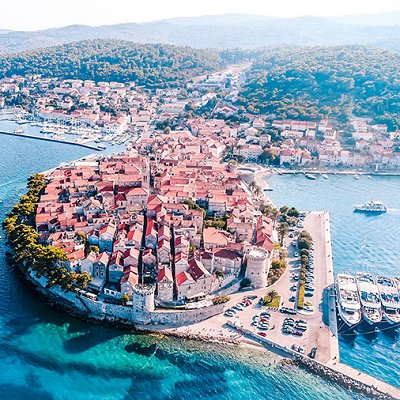
Korcula is a Croatian island in the Adriatic Sea. It has an area of 279 km2 (108 sq mi); 46.8 km (29.1 mi) long and on average 7.8 km (4.8 mi) wide - and lies just off the Dalmatian coast. Its 15,522 inhabitants (2011) make it the second most populous Adriatic island after Krk[3] and the most populous Croatian island not connected to the mainland by a bridge. The population are almost entirely ethnic Croats (95.74%). The island is twinned with Rothesay in Scotland.
The island of Korcula belongs to the central Dalmatian archipelago, separated from the Pelješac peninsula by a narrow Strait of Peljesac, between 900 and 3,000 metres (3,000 and 9,800 feet) wide. It stretches in the east–west direction, in length of 47 kilometres (29 miles); on average, it is 8 km (5.0 miles) wide. With an area of 279 square kilometres (108 sq mi), it is the sixth largest Adriatic island. The highest peaks are Klupca, 568 metres (1,864 ft) and Kom, 510 metres (1,670 ft) high.
Main settlements on the island are towns of Korcula, Vela Luka and Blato. Villages along the coast are Brna, Lumbarda, Racišce, and Prižba; Žrnovo, Pupnat, Smokvica and Cara are located inland. The island is divided into municipalities of Korcula, Smokvica, Blato and Lumbarda. The climate is Mediterranean. The island is largely covered with Mediterranean flora including extensive pine forests.
The main road runs along the spine of the island connecting all settlements from Lumbarda on the eastern to Vela Luka on the western end, with the exception of Racišce, which is served by a separate road running along the northern coast.[citation needed] Ferries connect the city of Korcula with Orebic on the Peljesac peninsula. Another line connects Vela Luka with Split and the island of Lastovo. Fast passenger catamarans connect those two ports with Split and the islands of Hvar and Lastovo.
|