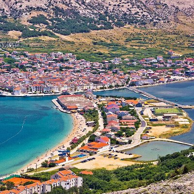
Pag is a Croatian island in the northern Adriatic Sea. It is the fifth-largest island of the Croatian coast, and the one with the longest coastline.
In the 2011 census, the population of the island was 9,059. There are two towns on the island, Pag and Novalja, as well as many smaller villages and tourist places. Pag is the only Croatian island that is administratively divided between two counties. Its northern part belongs to Lika-Senj County, while the central and southern parts belong to Zadar County.
Pag belongs to the north Dalmatian archipelago and it extends northwest-southeast along the coast, forming the Velebit channel. The island has an area of 284.56 square kilometres (109.87 sq mi) and the coastline is 269.2 kilometres (167.27 mi). It is around 60 kilometres (37 miles) long (from northwest to southeast), and between 2 and 10 kilometres (1.2 and 6.2 miles) wide.
The southwestern coast of the island is low (including the Pag Bay with the large Caska cove), and the northwestern is steep and high (including Stara Novalja Bay). Most of the island is rocky; smaller areas are covered with Mediterranean shrubs. The southeast of the island contains karst lakes Velo Blato and Malo Blato. The island's highest peak, at 349 metres (1,145 feet), is Sveti Vid (St Vitus).
Grapes, vegetables and fruit are grown in the valleys and fields. The northern area of the Lun peninsula is mostly under olive groves. Most communities on the island are connected by a road. A 300 m (980 ft)-long arch Pag Bridge connects the southern part of the island to the mainland. The Prizna–Zigljen ferry connects the northern part of the island to the mainland. The island has two towns, Pag and Novalja, and many smaller villages and communities, including Lun, Stara Novalja, Gajac, Kolan, Metajna, Dinjiška, Povljana and others. The island is divided between two counties, with Novalja, Stara Novalja, Lun and Metajna being part of the northern Lika-Senj County, and the remainder of the island south of an isthmus at Gajac, including the town of Pag, being part of the southern Zadar County.
|