Drogheda ("bridge at the ford") is one of the oldest towns in Ireland. It is located on the Dublin–Belfast corridor on the east coast of Ireland, mostly in County Louth but with the south fringes of the town in County Meath, 49 km or 30 miles north of Dublin. Drogheda has a population of approximately 41,000 inhabitants (2016), making it the eleventh largest settlement by population in all of Ireland. It is the last bridging point on the River Boyne before it enters the Irish Sea. The UNESCO World Heritage Site of Newgrange is located 8 km west of the town.
Drogheda was founded as two separately administered towns in two different territories: Drogheda-in-Meath (i.e. the Lordship and Liberty of Meath, from which a charter was granted in 1194) and Drogheda-in-Oriel (or 'Uriel', as County Louth was then known). The division came from the twelfth-century boundary between two Irish kingdoms, colonised by different Norman interests, just as the River Boyne continues to divide the town between the dioceses of Armagh and Meath. In 1412 these two towns were united, and Drogheda became a 'County Corporate', styled as 'the County of the Town of Drogheda'. Drogheda continued as a County Borough until the setting up of County Councils through the enactment of the Local Government (Ireland) Act 1898, which saw all of Drogheda, including a large area south of the Boyne, become part of an extended County Louth. With the passing of the County of Louth and Borough of Drogheda (Boundaries) Provisional Order, 1976, County Louth again grew larger at the expense of County Meath. The boundary was further altered in 1994 by the Local Government (Boundaries) (Town Elections) Regulations 1994. The 2007–2013 Meath County Development Plan recognises the Meath environs of Drogheda as a primary growth centre on a par with Navan.
The town was selected to host Fleadh Cheoil na hEireann for two years in 2018.
Places of interest include:
- Millmount Fort and museum
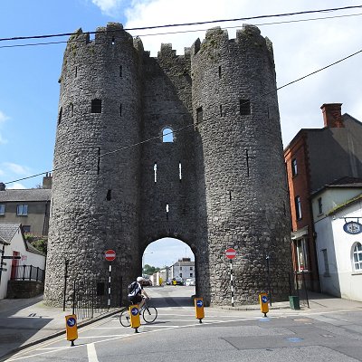
- Saint Laurence Gate barbican gate c. 1300s
- John Philip Holland memorial (sculpture commemorating submarine inventor)
- Boyne Viaduct
- John Jameson's residential home (not open to the public), and a Jameson distillery trail of malthouses in the town.
- Battle Of The Boyne Site, visitors centre
- Éamonn Ceannt's school (formerly St Joseph's CBS now operates as Scholars Hotel)
- Beaulieu House and gardens
- Mellifont Abbey
- Townley Hall nature trail and woods
- Princess Grace Rose Garden at St. Dominic's Park
- St. Peter's Roman Catholic Church, which houses a shrine of Oliver Plunkett
- St Peter's Church of Ireland church, on Peter's Hill
- Highlanes Gallery
- Augustinian Church 'The Passion Window' Harry Clarke Studio
|