I have listed the Cerdagne region as a single page because it is an entire, distinct community, for millennia isolated from the rest of the world. It is a carved out hollow, surrounded by the high Pyrennean Mountains, bordered by mountain villages. Most of these have now become ski resorts.
Originally, it was a massive glacier stretching from the mountain tops in the north, ending close to Martinet in Spain. The lower, and less famous, half of the hollow is in Spain. Eventually, global warming came along and the glacier retreated farily rapidy as far as the terminal morraines west of Bellver de Cerdnya. More millennia went by and then global warming re-commenced - receeding the glacier to Puigcerda briefly, before retreating again to Saillagouse where it must have remained for a considerable period before retreating once more to La Cabanasse where it left a huge semi-circle of morraines. Eventually, it retreated further northward, in several stages, until it fizzed out completely. At each stage, it left a huge lake behind.
At La Cabanasse, the lake overflowed, cascading eastwards, carving out the Conflent Valley all the way to the flatlands west of Perpignan. The rest of the melt-water flowed west and formed the Segre River, flowing through the gorge into the Ebro in Spain. Thus, three major rivers in France and Spain are born here.
Nothing remains of the glacier, of course, and only a few scattered lakes remain north of Font-Romeu, close to Le Angles where there is a wildlife park.
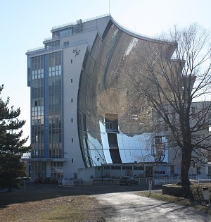
The hollow is a sun trap, which is why solar furnaces are built here. The original one is at Odeillo, close to Font-Romeu.