The border between France and Spain has not always been where it is now - along the peaks of the Pyrenees. It has fluctuated according to the strength of the powers in their day. In 1258 Salses was the frontier between France and the Realm of Aragon.
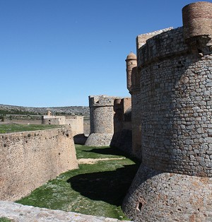
The fort here, built on the Via Domitia, the old Roman road from Narbonne to Spain, commands a narrow passage between the Mediterranean and the hilly hinterland, a route followed by Hannibal during his campaign against Rome. The fort was built by the Spaniards between 1497 and 1504 on the order of Ferdinand the Catholic, King of Aragon, to keep France out of the Roussillon region. Designed by Francisco Ramiro Lopez, the king's first artilleryman, the fortress of Salses is a masterpiece of military architecture, a notable example of the transition from medieval château (the fortress has a keep and round towers framing long curtains) to modern fortress (it is strictly geometrical with deep foundations).
With walls almost ten metres thick, the construction has three to seven levels connected by a labyrinth.
There were many conflicts between France and Spain between 1503 and 1642 when the French finally regained the fort. In 1691 the architect Vauban modified it by reducing the height of the keep and reinforcing the ramparts. In 1896 the town was destroyed following Franco-Spanish conflicts.
The kings of Aragon feature in the Perillos mystery, and in the 1960s, the French adventurer and writer André Malraux tried to obtain the building plans to get information about the subterranean waterways and chambers of the fort. According to a local of Opoul-Perillos, the wood that was used for the fort came from Perillos.
Today the visit of this historical site takes about 1 hour. From the five-story tower there are fine views in all directions.