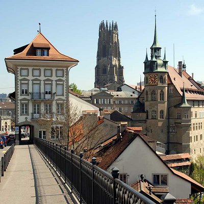
Fribourg has an elevation of 581 metres (1,906 ft) (in the Old City), and is situated 28 kilometres (17 mi) southwest of Bern. It is located on the Swiss plateau, and extends on both sides of the Sarine, which, in the vicinity of Fribourg, has cut deeply into the molasse. The Old City is located on a hill, only about 100 metres (330 ft) wide, which rises about 40 metres (130 ft) above the valley floor. Most quarters of the city are located on the High Plateau and the surrounding hills, which have an average elevation of 620 metres (2,030 ft). The valley floor is only settled in the area immediately around the Old City.
Fribourg has an area, as of 2009, of 9.3 square kilometers (3.6 sq mi). Of the built up area, industrial buildings made up 4.5% of the total area while housing and buildings made up 34.5% and transportation infrastructure made up 15.2%. Power and water infrastructure as well as other special developed areas made up 1.6% of the area while parks, green belts and sports fields made up 7.5%. Out of the forested land, 14.4% of the total land area is heavily forested and 2.6% is covered with orchards or small clusters of trees. Of the agricultural land, 6.9% is used for growing crops and 6.0% is pastures. Of the water in the municipality, 1.7% is in lakes and 4.0% is in rivers and streams.
The area of the municipality, which is relatively small for a city, covers an area of Molasse in the central part of Canton of Fribourg. The area is cut through from south to north by the tightly wound Saane/La Sarine, which has eroded a valley, in some places, to a depth of 100 metres (330 ft) below the surrounding Plateau. In general, the valley floor is between 200 and 500 metres (660 and 1,640 ft) wide. Le Lac de Pérolles, formed as a reservoir by Maigrauge Dam, the first Gravity Dam in Europe, in 1872, is located south of the city. The head of the Schiffenensee is located just 1 kilometre (0.62 mi) north of the city. At both of these artificial lakes, La Sarine covers nearly the entire valley floor.
The hills flanked on both sides by steep, largely wooded, slopes. To the east, the municipality reaches up the slopes of Mount Schonberg, which, with an elevation of 702 metres (2,303 ft), is the highest point in Fribourg. The river Galtera, also deeply cut into the plateau, flows between the mountain and the river, emptying into the Saane/La Sarine near the Old City.
The former village of Bourguillon lies within the municipality. Fribourg borders on Dudingen and Tafers to the east, Pierrafortscha to the southeast, Marly to the south, Villars-sur-Glane and Givisiez to the west, and Granges-Paccot to the north.
The region around Fribourg has been settled since the Neolithic period, although few remains have been found. These include some flint tools found near Bourguillon, as well as a stone hatchet and bronze tools. A river crossing was located in the area during the Roman Era. The main activity in the Swiss plateau bypassed the area to the north, however, and was instead centered around the valley of the river Broye and Aventicum. Therefore, only a few remains from the Roman era have been found in Fribourg. These include the traces of a wall foundation on the plains near Pérolles.
|