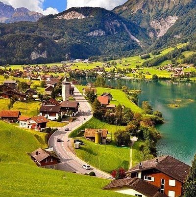
Lungern is a municipality in the canton of Obwalden in Switzerland. It encompasses Lake Lungern and, besides the village of Lungern, the settlements of Bürglen, Kaiserstuhl and Obsee.
The village of Lungern lies 750 metres (2,460 ft) above sea level, on the eastern shore of the Lake of Lungern and at the foot of the Brünig Pass. It is the highest village of the Sarneraa-Valley, in a basin open only to the north and surrounded on all other sides by steep and woody inclinations and rocks.
To the south-west the municipality extends to the Brünig Pass. On its north-western side, the municipal boundary is set by the Wilerhorn and Höch Gumme mountains, and includes the whole of the Lake of Lungern. To the east, the boundary reaches as far as the Hochstollen and Chingstuel mountains, and includes the Güpfi mountain and part of the Kleine Melchtal valley.
Besides the village of Lungern, the municipality includes the settlements of Kaiserstuhl and Bürglen that lie at the northern end of the lake, and Obsee on the south-western end of the lake.
The municipal district of Lungern has an area of 46.33 square kilometres (11,450 acres), of which 6.48 square kilometres (1,600 acres) are meadow and tilled land, 19.2 square kilometres (4,700 acres) are pastureland, 15.97 square kilometres (3,950 acres) are wooded and the remaining 2.91 square kilometres (720 acres) are unproductive.
The main sights of Lungern are:
- the old church tower (Alter Kirchturm), a neo-Gothic church, and the hamlet Obsee
- the Lungern-Turren cablecar to Turren and then hike to Schönbüel
- the underground shooting range
|