Like us on Facebook

MENU
Europe
England
Cumbria
Westmorland & Furness
Aldingham
Alston
Ambleside
Appleby
Armathwaite
Asby
Ayside
Backbarrow
Bampton
Barbon
Bardsea
Barrow-in-Furness
Baycliffe
Beetham
Biggar
Blawith
Blencow
Bolton
Bouth
Bowness
Brigsteer
Brough
Brougham
Broughton
Burneside
Cark-in-Cartmel
Cartmel
Cartmel Fell
Casterton
Clappersgate
Cliburn
Colby
Colton & Oxen Park
Coniston
Crackenthorpe
Crook
Crosby Ravensworth
Crosthwiate
Culgaith
Dacre
Dalton
Dent
Eamont Bridge
Edenhall
Elterwater
Embleton
Field Broughton
Finsthwaite
Flookborough
Gamblesby
Gleaston
Glenridding
Grange-over-Sands
Grasmere
Great Salkeld
Greenodd
Greystoke
Grizedale
Hawkshead
Hutton in the Forest
Ings
Ireleth & Askam
Kaber
Kendal
Kentmere
Kirkby-in-Furness
Kirkby Lonsdale
Kirkby Stephen
Kirkby Thore
Kirkoswald
Langdale
Langwathby
Lazonby
Leece
Levens
Lindal-in-Furness
Little Salkeld
Longsleddale
Loppergarth
Lowick
Lowther
Mallerstang
Matterdale
Maud's Meaburn
Melmerby
Middleton
Milburn
Milnthorpe
Morland
Mungrisdale
Nateby
Natland
Nentberry
Nenthead
Newbiggin-on-Lune
Newby Bridge
Nibthwaite
North Scale
Old Hutton
Ormside
Orton
Oxenholme
Patterdale
Pennington
Penny Bridge
Penrith
Penruddock
Piel
Pooley Bridge
Rampside
Ravenstonedale
Roa Island
Rydal
Sawrey
Scales
Seathwaite
Sedbergh
Sedgwick
Shap
Skelsmergh
Skelton
Skelwith Bridge
Slaggyford
Sockbridge
Soulby
Spark Bridge
Stainmore
Stainton
Staveley
Talkin
Tebay
Temple Sowerby
Thwaites
Tirril
Torver
Troutbeck
Ullswater
Ulverston
Underbarrow
Urswick
Warcop
Watermillock
Windermere
Winster
Winton
Witherslack
Woodland
Wreay
Yanwath
100 best things to do in England
Things to do in Watermillock


PLACE NAMES


Watermillock
The Square, Pooley Bridge - 01768 486 135
pbtic@lakedistrictestates.co.uk

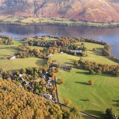
Watermillock is situated on the north side of Ullswater some seven miles south-west of Penrith, and a mile or so from Pooley bridge. Just out of sight is an impressive new church of dark slate, built to give the appearance of dry-stone walling, and is the work of local craftsmen. One attractive window shows the scene of Paul's conversion and in another he is preaching at Athens. The font keeps in rememberance five small children from this neighbourhood.

In 1891 the community as it was then was able to boast various trades operating in the parish along with two schools, a post office, two pubs and 46 farms. The last 100 years have seen so many changes throughout the country, and nothing like this amount of activity exists today.

In the early years a great deal of the higher land was forest and deer park, no doubt popular with visiting royalty. Substantial stone walls...the 'fell' or 'moor'dyke, often as high as 5 feet high generally marked the boundary between farmland and waste. The tenants until quite recently had certain privileges...for example, 'green hue' and 'fern bound' cutting brushwood as winter feed for cattle, and bracken for bedding or thatching. The forest was actualy enclosed in 1816 with some two thirds being converted to farmland, and the remainder left for the wild red deer. These days roe deer, badgers, foxes, buzzards, hawks, and herons roam free making it a naturalist's paradise.

Near the lakeside road stands Watermillock House, built in the late 17th century, with interesting mullioned windows and across the water one sees the long ridge of the Roman Road, High Street.


leonedgaroldbury@yahoo.co.ukFeel free to Email me any additions or corrections


LINKS AVAILABLE TO YOUR SITE