|
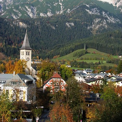
Saalfelden am Steinernen Meer is a town in the district of Zell am See in the Austrian state of Salzburg. With approximately 16,000 inhabitants, Saalfelden is the district's largest town and the third of the federal state after Salzburg and Hallein.
Although the Saalfelden area has always been the most populous of the historic Pinzgau region, the seat of the district administration is situated in the neighbouring town of Zell am See.
Saalfelden am Steinernen Meer lies at 744 m (2,441 ft) above sea level and its municipal area covers 118 km2 (46 sq mi). The largest proportion of the municipality is formed by the Saalfelden Basin (Saalfeldner Becken) situated between the Northern Limestone Alps ranges of:
- the Steinernes Meer high plateau to the north, forming the border with Germany
- the Leogang Mountains and the Biberg to the west
- the Hochkönig massif and the Salzburg Slate Alps to the east.
To the south the basin is generally open, running into the Zell Basin (Zeller Becken) with Lake Zell and the Salzach river - hence the term Zell-Saalfelden Basin Zeller-Saalfeldener Becken is also used for the whole valley - and enables a view of the High Tauern, especially the prominent Kitzsteinhorn and Wiesbachhorn peaks. The two basins are separated by a barely discernible valley floor divide. This trough is one of the largest inner-Alpine basins.
The main river in the basin is the Saalach. It rises in the upper Glemm Valley, empties into the basin south of Saalfelden and passes through it from south to north. A right tributary of the Saalach flowing through the borough of Saalfelden from east to west is the Urslau creek. A left tributary, the Leoganger Ache, empties into the Saalach from the west. In addition there are several smaller tributary streams. In the centre of the basin is the Kühbühel ("cow-hill") which is a good 100 m (330 ft).
The only lake in the expansive basin is the man-made Ritzensee, excavated for leisure purposes. Other artificial ponds have been laid out primarily for angling and tourism.
|