|
Immediately south of the Peak District's highest area,the Kinder Hills, the village and dale which give their name to this area are quiet and unspoilt.
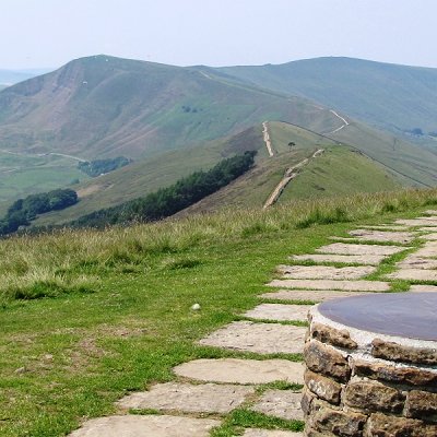
The valley offer delightful walking country with the rugged hills all around. Crowden Head at 2,070 feet is the highest point visible, but Win Hill, with its Roman road, Lose Hill, Mam Tor, Mount Famine and Rushup Edge are almost as high.
Mam Tor, more than 1,700 feet high, is known as the 'Shivering Mountain' because of the landslides which regularly occur, caused by the unusual composition of alternate layers of grit and shale. Near the top is an Iron Age camp covering 16 acres within a circumference of 1,200 yards. The Kinder Hills can be reached by the path called Jacob's Ladder which climbs over a shoulder in the hills, past a cross dated 1610.
During the winter months the famous white, or mountain, hares of Kinder can be seen zig-zagging across the faces of the slopes.
The village of Edale has a gentler appearance than many of the Derbyshire hill villages. In the church,the third on the site, is a Bible printed in English printed in 1541 by Edward Whitchurch. The parish register dates from 1633. This 19th century church is the third in three centuries.
Edale is a delightful little spot, with its pretty gritstone houses and lovely gardens, an inn (the Nag's Head), some 350 years old, and a beautiful wayside dell where a one-arch bridge crosses the Grinds Brook on its way to the Noe.
The Vale of Edale is a spectacular and unspoiled area with great appeal for walkers and climbers.
Hamlets in the valley usually have the word 'Booth' in their names ( Upper Booth, Barber Booth, etc). It is from Edale that the Pennine Way - an upland patch for experienced walkers - begins and continues until it reaches the Cheviots.
The village of Edale, otherwise known as the island valley, has two pubs, both of which at one time came under the jurisdiction of Fred Heardman). There is also a cafe, an excellent Peak Park Information Centre, and several campsites. Despite its popularity it has not been spoilt and manages to retain much of its charm.
Five packhorse ways converged here and there is a good example of a narrow packhorse bridge crossing Grinds Brook only yards from the Old Nags Head.
The aforementioned Pennine Way, Britain's first and most celebrated long-distance footpath, stretches 250 miles from Edale to Kirk Yetholm over the border in Scotland. This high-level route, which follows the Pennine backbone of England, was conceived by a certain Tom Stephenson in 1935, but it took thirty years of dedicated and persistent negiotation before it was finally opened on 24th April 1965. As many as 10,000 people a year start on the route, and although not all of these complete the walk, its popularity has led to erosion problems in certain parts.
Signs will be seen to Fred Heardman's Plantation. The plantation has been dedicated to the memory of Fred Heardman, a legendary figure of the Peak District who was, for many years, the landlord of both the Old Nag's Head and the Church Inn ( now the Rambler Inn). Known to his friends as Bill the Bogtrotter for his exploits on arduous walks and runs in the Peak, he became a rural district councillor and fought, fortunately very successfully, against the industrialisation of this attractive valley.
|